
To get the ball rolling for 2016, first an update on the current weather and outlook, then soon to come, a wrap-up of how 2015 played out. Going forward I will try to keep you mags up to date on weather and snow conditions here.
For general information for travelers to Chile, such as weather patterns, ski area data, DIY options, lodging, backcountry, and volcanoes, this TGR thread is the place to go http://bit.ly/Chileskiguide
Chile just got a major precipitation event the last few days, the first of the year. It hasn´t quite ended yet, but has so far produced almost 10 times the normal rainfall to date for Santiago, mud/rock slides, 4 million people without tap water, flooding and general despair. So, once again, it is all or nothing: Chile has had 9 years of below average rainfall, and up until a few days ago, only 12mm of rain had fallen in Santiago this year. It is now over 100mm, and this is 1/3 of the normal annual total. With abnormal being the new normal, Santiago now has accumulated more rainfall than Temuco, which normally gets about 4 times more, but is now running a 60% deficit.
This begs the first question: is it snowing? Well, it wasn´t, and with it raining all the way up to 3,600m, a lot of rock and dirt came tumbling down, but it started to snow last night and this is what Valle Nevado looks like now:
This will probably make no difference at all to the ski season snowpack, as it will probably melt before it gets cold enough to really accumulate snow for the lift openings.
The second question is: What do the meteorologists say we can expect for Chile? With flooding events in various other southern cone countries, El Niño would appear to continue to affect the weather. However all the signs are for the ongoing decline of El Niño to end by about June, and then become neutral (or "La Nada"), with a good chance of La Niña (dry) taking hold by September/October. Now all this is a statistical probability, there being other possibilities as well, and only 60 years of El Niño history for background.
This El Niño event, which was first announced in 2014, did not produce above average rainfall for either 2014 or 2015. On the contrary, they were both below normal. According to the local weather service, the weakening of the south pacific high pressure system was the missing piece of the rainfall puzzle. This high pressure system is so powerful it creates the Atacama desert of Peru and northern Chile, but once weakened, it allows storms circulating at higher latitudes to move north. This normally occurs as a consequence of major warming of the east ecuatorial Pacific and a change in wind direction, both associated with El Niño, but for 2015, it only happened moderately at the end of the rainy season, starting in August. Thus, in spite of regular rainfall until November, it did not make up for the lack of rain in the normally rainiest months of May-July.
Looking back at the previous two major El Niños, we find two totally different post-Niño scenarios. After the 1982 event, there was no La Niña, and the 1983 and 1984 ski seasons were outrageously good. After the 1997 event, la Niña took hold and the central zone ski areas didn´t even open in 1998. Another moderate event, the 1986/7 El Niño, got the ski areas running in EARLY MAY 1986! Yes, and I skied knee-deep in May on normally rocky faces. 1987 was the rainiest year of the 20th century, and both years we skied the central zone well into October.
So, where are you putting your money this year?
I will go partially out on a limb. Having observed the shivering bushes, the ant and condor activity, the frequent "marejadas" (heavy seas or swells which have battered the coast this year), and this most recent rain event, I feel the chances of a wet fall and early start to the ski season are good (June). As for the rest of the season, it is definitely too soon to venture an opinion, but I am optimistic. There have been too many mediocre seasons lately not to have an epic one now!
For the studious, here is a historical perspective on the current El Niño:

Results 1 to 25 of 193
Thread: Ski Chile 2016
-
04-18-2016, 04:22 PM #1
 In awe
- Join Date
- May 2014
- Location
- Santiago Chile
- Posts
- 2,036
Ski Chile 2016
Last edited by Casey E; 08-25-2016 at 09:17 AM.
-
04-18-2016, 04:35 PM #2

 Registered User
- Join Date
- Mar 2010
- Location
- BROulder
- Posts
- 2,884
Good luck this season !!!
-
04-19-2016, 05:56 PM #3
In awe
- Join Date
- May 2014
- Location
- Santiago Chile
- Posts
- 2,036
About 30 cm accumulated since Saturday, with the Cordillera Central making a nice scene from the Club de Polo in Santiago:
El Colorado got a nice even layer, which is melting fast:
More snow is forecast for this weekend, and if that is followed up with a weekly snowfall for the next 3 weeks, some of this snow might actually make it to the beginning of winter, and maybe we will be skiing sooner than expected.....
-
04-20-2016, 06:26 AM #4
 Registered User
- Join Date
- Feb 2007
- Location
- Idaho
- Posts
- 1,390
Yeah man! Northern hem El Niño didn't behave as was expected. Maybe the same for the South.
I'll likely do Portillo late August again. I hope to meet up with you some time. Thanks for getting the thread started.
-
04-20-2016, 05:17 PM #5
In awe
- Join Date
- May 2014
- Location
- Santiago Chile
- Posts
- 2,036
Good lord, could this be true?
-
04-21-2016, 08:31 AM #6
In awe
- Join Date
- May 2014
- Location
- Santiago Chile
- Posts
- 2,036
For what it is worth, below is the AMJ quarter rainfall forecast from the Chilean meteorologists. This runs north to south with the normal range of precipitation in red and the predicted rainfall in green. It is surprisingly pessimistic.
http://www.meteochile.gob.cl/predicc...tadistica.html
-
04-21-2016, 12:41 PM #7
 heartcore
- Join Date
- Jan 2006
- Location
- Vanity Fair
- Posts
- 2,724
Why do you consider it surprising? Originally Posted by Casey E
 Ich bitte dich nur, weck mich nicht.
-
04-21-2016, 05:03 PM #8
In awe
- Join Date
- May 2014
- Location
- Santiago Chile
- Posts
- 2,036
Just 2 weeks ago, El Mercurio published an article quoting the same source saying this year was much more "auspicious" for rainfall over last year, and "we should see more snow to June". Originally Posted by klar
http://impresa.elmercurio.com/Pages/...aId=1&bodyid=3
This, together with the forecasted transition from Niño to neutral, which in normal times translates to "normal to above normal rainfall". They issued the report about the time the recent storm started, and we since have already received about the total normal Q2 rainfall.
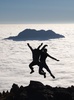
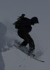
Talking about abnormal being the new normal (I won´t say that word again, don´t worry), my friend Slava got some nice turns in on Tuesday. I guess he is ballsier than me, I was sure there was still too many rocks to be found. So skiing powder in April can actually happen! A couple of his photos here:
Looking north from the Cono, where they descended:
-
04-22-2016, 12:34 AM #9
heartcore
- Join Date
- Jan 2006
- Location
- Vanity Fair
- Posts
- 2,724
The discussion about what is normal and whether that has changed/ is changing is entirely legitimate. I wasn't going to argue there!
You might find this series about skill and verification of probabilistic forecasts (that is what those 3 months forecasts are) interesting:
Part1
Part2
Part3
re ENSO development, hmm, super hard to figure out when and to what extent correlation equals causation when it comes to the fate of specific ski seasons imo.
turns look great!Ich bitte dich nur, weck mich nicht.
-
04-22-2016, 03:13 AM #10
Mike Pow
- Join Date
- Apr 2005
- Location
- Between a rock and a soft place. Aberdare and The Brecon Beacons, Wales
- Posts
- 3,294
 Originally Posted by Casey E
I would have too.
Looks magic
-
04-22-2016, 02:24 PM #11
In awe
- Join Date
- May 2014
- Location
- Santiago Chile
- Posts
- 2,036
Time for the 2015 recap!
Central zone - 2015 started late, but went well into October. Following a severe drought, the first real flakes flew mid July, providing a thin base until August 6 when a late 3 day storm really turned the season around. About 1.5m or 5 feet fell during this last event. Both storms were forecast to dump much more than actually happened (snow forecast was 3 times greater). So with only 2 big snowfalls during the regular storm season, the ski areas got through to September. Then it started snowing again, with almost weekly mid size dumps through October. Portillo got more than the 3 valleys in July and August, but still shut down late September. The 3 Valleys stayed open, partially, until late October, with powder being skied in October. Nice thing about the central zone: it can dump cold and dry anytime from April to October.
Meanwhile, in Southern Chile, the snow arrived earlier and ended late. The most severe drought in decades ended in May, when the rains came roaring back. By mid June, there was enough snow for Corralco to open, but Chillan was still closed. I opened my season at the beginning of July in Corralco, where there was plenty for snow for out of bounds cruising. The snow just kept piling up in the Araucania region, with warm spells and rain mixed in, and Corralco closed at the end of October with a significant upper mountain base (2m+). Chillan got a few storms, but didn´t get up to the level of an average season.
Overall, the impact of El Niño, which is usually excessive precipitation, was absent, with +-20% rainfall deficits all over Chile, bar the notable exception of the Araucania region (Corralco, Villarrica), which had a normal year.
Here are photos from early July in Corralco, and my season closer there the last week of October:
JULY 5, 2015
October 22, 2015
-
04-22-2016, 03:28 PM #12
 Registered User
- Join Date
- Jul 2015
- Posts
- 475
I want to thank Casey for all the great beta in last year's thread. Really helpful stuff. We were fortunate to hit Valle the Friday of that August 6 storm, and had a great time through Tuesday, totally luck-boxed the timing. Jong hint -- a white out above tree line should be respected!
-
04-23-2016, 10:05 AM #13
 KING RATBAGGER !!! ...
- Join Date
- Jan 2009
- Location
- tourin BC
- Posts
- 2,773
Its funny, just this week I was wondering when this thread would start. Did my spidy senses tell me it was snowing somewhere ???
Coz it sure aint snowing here lately ... rain above 2500m today ...We, the RATBAGGERS, formally axcept our duty is to trigger avalaches on all skiers ...
-
04-26-2016, 01:48 PM #14
In awe
- Join Date
- May 2014
- Location
- Santiago Chile
- Posts
- 2,036
It snowed again on the weekend, this time cold. 30cm around 3,000m and some down to 1,900m.
Valle Nevado looks ready to open (but it isn´t) -
Warm weather took the snow off the road by my place in La Parva, but the runs are accumulating snow -
A bit more is forecast for Sunday/Monday, so my hope of weekly snowfalls to make this stuff count may come true. We are still weeks away from knowing whether the season really will start early or not though, as a freezing level at 3,500m-3,900m, as forecasted, decimates the base....
-
05-02-2016, 10:47 AM #15
In awe
- Join Date
- May 2014
- Location
- Santiago Chile
- Posts
- 2,036
My boys snowshoed up La Parva on the weekend, still looking good above 2,800m:
Las Aguilas chair
La Pared
La Nevada
While the snow melts away at the base, with rocks "flowering", the upper mountain looks likely to hold this even, firm base of around 50-70cm, at least on southern exposures.Last edited by Casey E; 05-02-2016 at 11:14 AM.
-
05-04-2016, 09:45 AM #16
In awe
- Join Date
- May 2014
- Location
- Santiago Chile
- Posts
- 2,036
Volcan Villarrica, where I am now, needs a lot more snow, the ski area being mostly bare. Lots of smoke though!
-
05-10-2016, 03:52 PM #17
In awe
- Join Date
- May 2014
- Location
- Santiago Chile
- Posts
- 2,036
The volcanic activity in Chile is a dynamic affair, which provides an additional adrenaline dimension to resort and backcountry skiing. The current state of affairs involves 4 "yellow alerts", with restricted access around the craters, which are often visibly justified by spewing smoke and ash. This class implies a probable time to eruption of "weeks/months", but in reality, often not at all. More info, and live webcams, here: http://www.sernageomin.cl/volcanes.php
Going north to south they are:
Planchon - Peteroa (200km south of Stgo): not smoking visibly right now, but has had seismic activity, and has been on alert for a long time.
Volcan Chillan Nuevo (400km south): Right above the ski area, this most active of the Chillan chain has had several episodes this year, with smoke and ash and hydro-thermal activity, plus the appearance of a new minor crater. There is a 2km restriction around the blast site, which doesn´t quite reach the ski lifts, but may influence the opening of the ski area. This is what it looked like yesterday, when the plume reached 1,700m above the crater:
Volcan Copahue (500km): Remote and right on the border of Argentina beside the Caviahue ski area, this one has been smoking for a couple of years now. It emits sulfur dioxide and the plume reached 1,400m in April. Poor Caviahue. It also has access restriction. This is what it looked like last October (from Volcan Lonquimay):
Volcan Villarrica (or "Rucapillan", 700km): After the March 2015 major eruption, this volcano was closed for touristic activity for 8 months. although many independent groups skied it (half-assed enforcement of the restriction). It continues to belch smoke, mostly white, sometimes black, sometimes thick and furious, sometimes barely visible. Here is what it looks from across the lake, and from a trek we did south from the ski area last week:
Word is the Villarrica ski area will reopen this year. We saw some minor work going on, but I doubt the area will suddenly become well managed and that forlorn lift you see above be open often during the season. By the way, "Rucapillan" means "house of the devil" or "spirit" in the Mapuche language, Mapudungun. Lets hope it doesn´t get riled up again this year....Last edited by Casey E; 05-13-2016 at 03:12 PM.
-
05-13-2016, 03:11 PM #18
In awe
- Join Date
- May 2014
- Location
- Santiago Chile
- Posts
- 2,036
Back to El Niño, which would seem to be the culprit behind the unusual central zone snowpack above 2,800m this year, which, at 20-60cm, is a first in a couple of decades.
The latest ENSO update is now titled "ENSO Alert System Status: El Niño Advisory / La Niña Watch". While El Niño conditions persist in much of the Pacific, the decline continues, and "La Niña is favored to develop during the Northern Hemisphere summer 2016, with about a 75% chance of La Niña during the fall and winter 2016-17".
Meanwhile, the physical evidence of El Niño in Chile can be found in the unseasonable minor precipitation events in the central zone (with more in the forecast), and the dramatic waves of dead sea fauna along the Chilean coast. While there is no certainty as to the causes, El Niño is a prime suspect, with warmer sea water leading to greater quantities of algae, which kill other species by consuming oxygen in the water or filling it with toxins.
Regardless of the cause, the events have been dramatic, including the intense "red tide" toxic algae bloom:
600 tons of sardines floating in a fishing village in Los Rios
Razor clams blanketing beaches in Chiloe
Portuguese man o' wars floating onto beaches all along the coast
Waves of dead langostinos in Arica, the extreme north
Hundreds of whales beached and rotting in the far south (Golfo de Penas) (may not be related to warm water though)
Farmed salmon dying by the thousands in their cages and then thousands of tons are getting dumped out to sea
Fisherman in Chiloe are raising hell to get government help, and the American and Canadian governments are recommending not to travel there.
So life is not good for fisherman, especially in southern Chile. El Niño for some, at least, sucks.
-
05-13-2016, 03:22 PM #19
 No I'm not an Australian
- Join Date
- Dec 2003
- Location
- Seattle
- Posts
- 33,925
Argentina question for the Chile '16 thread. Does anyone know if Catedral has any ongoing problem/operating issues after last years landslide?
Originally Posted by Downbound Train
-
05-15-2016, 07:34 AM #20
Registered User
- Join Date
- Feb 2007
- Location
- Idaho
- Posts
- 1,390
^^ I think Snowbrains is based there in southern winter. You might check with them.
-
05-17-2016, 12:00 PM #21
In awe
- Join Date
- May 2014
- Location
- Santiago Chile
- Posts
- 2,036
The Chilean weather service has now published their monthly update for the MJJ quarter El Niño and precipitation forecast
http://www.meteochile.gob.cl/predicc...climaticas.php
Summed up, normal precipitation is expected in Santiago, but further south, below normal (as has been the case so far this fall), which looks like this:
There has been lots of clouds around this month, but not much real precipitation, and it is not cold yet. In any case, I have a basic rule of thumb which is "Any snow that falls before mid-May is basically lost in terms of winter snowpack". Lets hope this doesn´t hold this year, but the snowline is currently rising, not falling, and the snow forecasts have been consistently wrong (less precipitation than forecast).....
-
05-17-2016, 02:05 PM #22
heartcore
- Join Date
- Jan 2006
- Location
- Vanity Fair
- Posts
- 2,724
It was operating as normally as it ever does last year after the landslide, unless you are talking about some other landslide..? Originally Posted by PNWbrit
Ich bitte dich nur, weck mich nicht.
-
05-28-2016, 08:08 AM #23
In awe
- Join Date
- May 2014
- Location
- Santiago Chile
- Posts
- 2,036
Looks like there is a stream of fronts heading our way, this is probably exaggerated, but a dry May might end with a good dump, and June start with a bang:
-
05-29-2016, 07:38 AM #24
Registered User
- Join Date
- May 2016
- Posts
- 3
Need a riding partner in chile
Hey guys I'm keen to hike/slackcountry a few sick lines in chile when we find out where the best snow is !!! Let me no if anyone's keen iv got no plans and have nowhere to be just need another person as I don't want to solo hike my first time in the Andes.
-
05-30-2016, 12:03 PM #25
Registered User
- Join Date
- Feb 2007
- Location
- Idaho
- Posts
- 1,390
Portillo reporting 50 cms and more to come. Opening week has always been priced at a discount. This would be the year to hit it.

 Reply With Quote
Bookmarks