
Feel free to post relevant observations here, tr's are better placed in the main forum.
We've had somewhere around a foot and a half of fresh in the last 2.5 days that has 2 buried layers of rime crust in there. The strong to moderate Westerly and WNW winds have done a good job of transporting that snow to the East, SouthEast and in some cases the NE aspects. Two days ago I was observing drifts in the 8"-24" range on the East slopes. This is when we only had 4" fresh. I haven't been up in the last two days but i can only assume they are getting deeper. Those that are looking to tour Alta for a lap down main chute should be weary of the cross loading on the high shoulder and the top loading on the smaller slopes lower down the shoulder (just above wildcat). The anchors aren't much help for the new layers, since the new snow and recent layering is on top of the rocks. If you really feel you must have a look at lower shoulder, please rope up. Also remember to look for others coming up the cat track before you put a slope cut above them. Make sure and bring your gear and have fun.
edit: BCC guys, i don't think you've been getting as much as LCC out of this one but does anyone know the storm totals over there?
Don't forget to call the avy center. They updated the report last night.
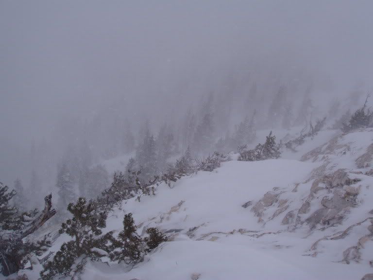
Rime:
more rime. winds coming left to right in the photo:

Results 1 to 17 of 17
-
11-14-2005, 11:16 AM #1

 Registered Offender
- Join Date
- Jul 2004
- Location
- not far from snowbird
- Posts
- 2,244
Current Conditions/Obs from the Wasatch 05-06
-
11-14-2005, 11:41 AM #2
Registered Offender
- Join Date
- Jul 2004
- Location
- not far from snowbird
- Posts
- 2,244
FYI, steep areas with last years snow have been slabing out with regularity. The Pipeline Bowl could have problems if it were weighted by a slough coming off the upper cliffs, center chute or just skier trigger if it is that sensitive.
-
11-14-2005, 05:30 PM #3
Registered User
- Join Date
- Dec 2004
- Posts
- 493
I avalanched High Rustler this afternoon(November 14) with a ski cut. Slide was the skier's left side, about 30 feet wide and up to about 20" deep running on the Friday old rain crusted surface.
It pulled out other sections as it ran, spreading to about double the original width and leaving debris just above the cat track.
Backed off of Gunsite earlier and would want zero to do with Baldy chutes.
When we reported the slide, Titus (snow safety) told us winds on top of Baldy were gusting to 106mph.Last edited by wra; 11-14-2005 at 05:32 PM.
-
11-14-2005, 06:07 PM #4
Registered User
- Join Date
- Sep 2005
- Posts
- 81
Windy!
I'm guessing 106mph may be enough to move some snow around. What does the windchill work out to be if ambient air temp is 25-degrees Farenheit? Ch-ch-chilly!
P.S. Be careful out there.
-
11-14-2005, 07:24 PM #5
Registered Offender
- Join Date
- Jul 2004
- Location
- not far from snowbird
- Posts
- 2,244
11-14-05
i kinda figured some of those things would end up crossloaded but you never know till you go and see. i did see a lot more people than i ever wanna see while touring alta at just before 0-dark-30. i went up to take a look at a the west and north aspects and it was as expected. the winds were nuking and loading the slopes further down that our usual. terrain features caused the usual eddies to load up other aspects as well. aside from the low vis, the pillows were easily noticeable and avoidable. the west aspects were loaded at the top with soft, less consolidated pillows that had been rescoured and deposited lower down the slope into stiffer slabs breaking 1.5-2' deep and not running very far. the closest one i observed ran between discontinuities in the snowpack (ie rocks and trees). the stiffer the slab the further the crack runs but don't discount the soft small ones. the rocks are still there, no need to hurry and uncover them.
Last edited by AltaPowderDaze; 11-15-2005 at 12:09 AM.
-
11-15-2005, 04:30 PM #6
 Hiding in AK
- Join Date
- Oct 2003
- Location
- Was UT, AK, now MT
- Posts
- 14,568
Suprisingly more stable than I thought it would be today on NE and E aspects.
Baldy shoulder had some pillows that were sensitive to the weight of a skinning skier.

Main Chute would have been stupid today. Atleast from our viewpoint and the extensive windloading wall to wall on the upper 2/3rds of the couloir.

At around 10.5k? east aspects had nice snow and remained nice throughout the day. This particular slope had no signs of windloading, suprisingly. No pillows, no chalky snow, nothing. Just new accumulation from the storm. The only windloading was at the top of the ridge, lee of the cliff bands.

-
11-18-2005, 09:49 PM #7
Hiding in AK
- Join Date
- Oct 2003
- Location
- Was UT, AK, now MT
- Posts
- 14,568
North and East facing slopes are still harboring nice snow. Did see a point release on an east facing slope that started from a cliff band. Ran 300-400 vertical, shallow, and fanned out maybe 50 ft. wide.
Starting to get a bit of surface hoar on shaded ridges. Nothing too exciting yet.
-
11-22-2005, 07:57 PM #8
Hiding in AK
- Join Date
- Oct 2003
- Location
- Was UT, AK, now MT
- Posts
- 14,568
The n-nw slopes on Baldy shoulder are turning into 1.5ft of depth hoar. Nothing but a bunch of faceted crap. Most of the areas around the rock outcroppings in Little Chute (N. Facing) and shallow snowpack areas are faceted as well.
These cold clear nights suck.
-
11-28-2005, 03:25 PM #9
Hiding in AK
- Join Date
- Oct 2003
- Location
- Was UT, AK, now MT
- Posts
- 14,568
11-28-05
Dug a few pits on N facing slopes at elevations arouind 10.5k.
Snowpack was shallow (2-3ft) on a N facing slope. The winds have been from the N-NW for the past week or so. Found 6-8" of sugar with the new snow (1-2ft) sitting on top of it. Found unimpressive Q2 like shears and failure with four moderate taps from the wrist.
My non-avy professional impression: The new snow load seems light enough and not wind affected enough to form a heavy enough slab to rip on the 35 degree slopes we were on. But with a potential heavier snow load, things could get spooky.
We'll see.
-
11-29-2005, 12:04 PM #10
Hiding in AK
- Join Date
- Oct 2003
- Location
- Was UT, AK, now MT
- Posts
- 14,568
Short day today.
Some people on the trail stopped to admire the new light skis. Designed for the fat and slow dufus crew who spend more time reading books than getting out skiing.

NE facing:33 degrees (?):Broke from the ground on two light taps from the wrist:Shovel shears are visible right and left in the photo.

Snow was more supportable today. Made for more fun, less wallowing.

-
11-29-2005, 10:14 PM #11
 mutant
- Join Date
- Nov 2002
- Posts
- 9,543
Welcome to my hell! That sucks. Turns look good however.
-
11-30-2005, 11:32 AM #12
Hiding in AK
- Join Date
- Oct 2003
- Location
- Was UT, AK, now MT
- Posts
- 14,568
11-30-05
Early in, early out today.
8-10" of new in Grizzly today. Came in much heavier than the last storm.

Sticking to the trees.

The turns were nice today. Very supportable snow in the trees.

But the winds were howling up the canyon, and the storm was intermittent.

Didn't dig anything today. But this storm layed it in thick and cohesive on the slopes I was on today. East facing slopes looked lighter and more tempting. But being solo, I didn't venture anywhere steep.
Skied past Wow on the exit. He seemed to have quite a large group today. 10 people? Teaching a class perhaps?
-
12-04-2005, 03:58 PM #13
Hiding in AK
- Join Date
- Oct 2003
- Location
- Was UT, AK, now MT
- Posts
- 14,568
Didn't find much to ski today with the tricky conditions. But had fun walking around.

While digging a pit on this N facing slope around 9500 ft, the slope collapsed, sympathetically releasing the area in red.

Breaking from the facets buried near the ground.

A steep, rocky rollover was the culprit. Sensitive hangfire was release with some stomping.


Cold and windy day in the mountains.

-
12-04-2005, 03:59 PM #14
Registered Offender
- Join Date
- Jul 2004
- Location
- not far from snowbird
- Posts
- 2,244
12-4-05
the avy report is dead on today. lots of activity.
Current Conditions:
Blizzard conditions rage in the central Wasatch high country this morning with heavy snowfall and blustery winds. Overnight, the mountains from Ogden to Salt Lake picked up another 8-12” in the past 24 hours, pushing storm totals to 2-3’ over the two days. Densities are in the 6-8% range despite periodic graupling. The west to northwest winds along the ridgelines intensified this morning to 35-45mpg with gusts to the 60’s but this should ease off late morning as the disturbance moves through. Temperatures plummeted to the single digits and below zero above 11,000’.
Avalanche Conditions:
Avalanche workers this morning reported heavy drifting at most elevations and aspects with the gusty and swirly winds. For backcountry travelers that make it into the high country, human triggered slides in the new snow will be likely on all steep drifted slopes, with a very distinct possibility of some stepping down into the older, weaker snow layers. Mostly confined to mid and upper elevation northwest through north through east facing slopes, these larger slides may be greater than 3-6’ deep and more than a few hundred feet wide. Furthermore, these larger slides may be even more pronounced in the outlying areas, such as the Park City ridgeline, Mill Creek, and the Provo area mountains. Cornice dropping, test slopes, and conservative slope cuts should reveal some good information, but today’s not the day to hang it out.
Headlining the avalanche news from yesterday is a skier released slide in No-Name bowl off the Park City ridgeline, a north to northeast facing slope at about 9800’. Details are still filtering in, but it appears that with eleven tracks already on the slope, a skier released the entire bowl 3-5’ deep and possibly 600’ wide. The slide not only engulfed the skier, but his three partners waiting for him below. All were partially buried, with one near-complete burial, but everyone came out miraculously unscathed. Avalanche control work in both Big Cottonwood canyon and the Park City areas continue to pull out slides to the ground and up to 7’ deep in uncompacted terrain.
Bottom Line:
The avalanche danger is CONSIDERABLE with human triggered avalanches likely on steep drifted slopes, with the real potential for them to step down into older faceted snow. Naturals may be possible in upper elevation areas that received the most snow and wind. Avalanches may be triggered at a distance, and as evidenced by yesterday’s close call, tracks are not necessarily a sign of stability with the current snowpack.
Mountain Weather:
-
12-04-2005, 04:25 PM #15
Registered Offender
- Join Date
- Jul 2004
- Location
- not far from snowbird
- Posts
- 2,244
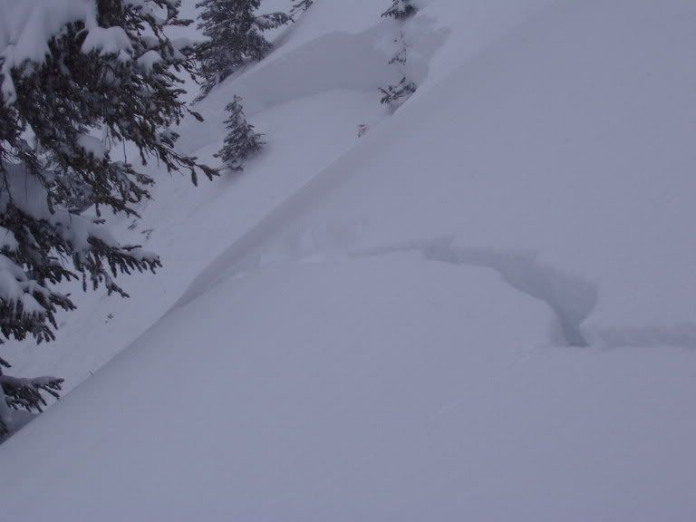
12-04-05
sorry for the poor pic quality but with the blowing snow our vis was limited.
this slope failed on faceted snow at the ground. the crack goes about 150' and remotely released the slope 150' behind the pic.

this is the pit that was being dug at the time of the collapse. you can see that the crack ran from the ground in the pit.

another slide that seemed to be a natural off of clayton peak.


-
12-06-2005, 08:16 PM #16
 Irrie Rasta Dog Copilot
- Join Date
- Apr 2005
- Location
- A LSD Steakhouse somewhere in the Wasatch
- Posts
- 13,259
12/06 Silverfork
snow stable on skin up from twin lakes pass.
East bowl windscoured & bony a few sensitive wind drifts.
Lower angle protected trees nice
While digging a pit on Flanigans N facing ~9600' partner came down to help,
when slope fractured on both sides. Sympatheticly releasing slab skiers right
Fracture aprox 5-6' to ground skiers left

Skicuts released new snow windpockets, no additional collapsing or deep instabilities noticed on decent to SF floor.

However on trip down from eagle express I hammered into a wind drift double ejectto and shit it blew out the whole rear heel lock of my naxo. Takin this as natures way of telling me to ride inbounds tommarrow. Looks like my next tour will be S. facing on alpine wreckers. Naxo has always done me right so I'm fairly sure they will give me the nx21 upgrade."When the child was a child it waited patiently for the first snow and it still does"- Van "The Man" Morrison
"I find I have already had my reward, in the doing of the thing" - Buzz Holmstrom
"THIS IS WHAT WE DO"-AML -ski on in eternal peace
"I have posted in here but haven't read it carefully with my trusty PoliAsshat antenna on."-DipshitDanno
-
12-07-2005, 03:35 PM #17
Registered Offender
- Join Date
- Jul 2004
- Location
- not far from snowbird
- Posts
- 2,244
12-07-05
hey look, no tracks!

E thru SE seem to have 8-12" new snow instabilities that appeared managable but i bet there are places where even the new snow would be unmanagable (see above). i'm still giving the 35-45* shady slopes some time to adjust. anybody had a look on the shady side lately? i did get to see some cracking from the storm and a few old small crowns. didn't look like they stepped down. they were shallow, just off the ridges and pockety.


 Reply With Quote
Bookmarks