
Who's familiar with the concept of "Alpha Angle" or "Runout Angle"? Who uses it?
This little Backcountry Magazine article provides a decent intro from the skier's perspective (IMHO)...
Mountain Skills: Understanding Alpha Angles
I'd love to know who out there is using alpha angle concepts routinely (especially for backcountry travel), who's hearing about it for the first time, etc.
View Poll Results: Do you know/use alpha angle concepts?
- Voters
- 35. You may not vote on this poll
-
Know it, use it often.
1 2.86% -
Know it, use it occasionally.
7 20.00% -
Know it, rarely/never use it.
19 54.29% -
Never heard of it, seems potentially useful.
4 11.43% -
Never heard of it, seems pretty useless.
1 2.86% -
Huh? I don't get it.
3 8.57%
Results 1 to 14 of 14
-
12-12-2016, 10:06 PM #1

 Rider of snow and water
- Join Date
- Jan 2011
- Location
- Burlington USA (just west of VT)
- Posts
- 57
 Alpha Angle / Runout Angle — who knows it? who uses it?
Last edited by grayson; 12-12-2016 at 11:34 PM.
-
12-12-2016, 10:15 PM #2
 Reunite Gondwanaland!
- Join Date
- Jan 2009
- Location
- in a suite of vigorous disturbances
- Posts
- 2,309
I always think of Alpha Angles as relevant for planning purposes (residences, roads, chair lifts, etc) more so than backcountry travel or skiing.
If I'm standing in a potential run-out zone, I'd probably just gtfo instead of measuring the AA.
-
12-12-2016, 11:25 PM #3
 *NOT* an expert
- Join Date
- Oct 2003
- Location
- 9,300ft
- Posts
- 22,979
Useful for planning as TT mentions. Ian McCammon showed me a map tool for that in 03. But really I rarely of ever need to use that.
I use alpha angle as a teaching tool for students to illustrate if an area is a potential runout when above treeline where runout Zone visual indicators are not obvious.
Outside of awareness and planning, max theoretical AA of 18 is silly outside of maritime zones when climax avalanches (R5) are forecasted. 18 degrees is hard to avoid. Try it with a map tool.
Easier to say be wary in runout zones and avoid if possible, consider no go vs mitigate with travel techniques if you can't reasonably avoid. Originally Posted by blurred
-
12-17-2021, 05:11 PM #4

 ____________________
- Join Date
- Sep 2008
- Location
- Not Brooklyn
- Posts
- 8,494
Bump.
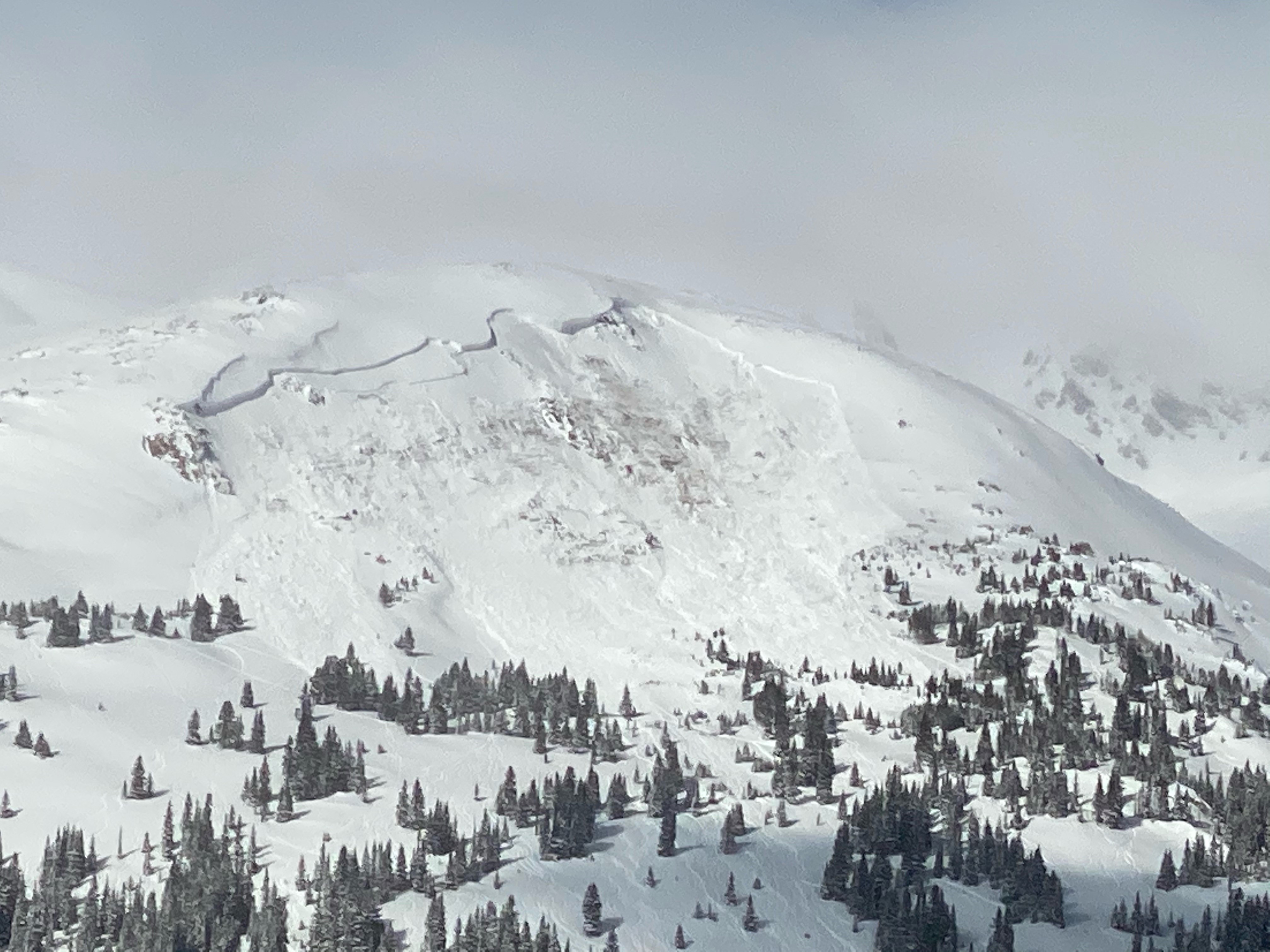
Snapped this photo of a party transitioning in place that I wouldn't have chosen:
I want encourage everyone to think about what is above them when they're out touring. These guys skied a very mellow slope, but transitioned under the runout of a slide path. Now, I think it was pretty damn unlikely that they would get buried in that spot today, but I still think it was an unnecessary risk, especially since when they started down, the slope wasn't even steep enough for turns. So they could have transitioned at a lower, safer spot without really missing out on much at all.
If you learn how to measure alpha angles, both before and during a tour you can avoid this situation. 100 years avalanches typically have an 18-22 degree alpha angle. Here is an old Wildsnow article on the topic and pic to demonstrate the concept:
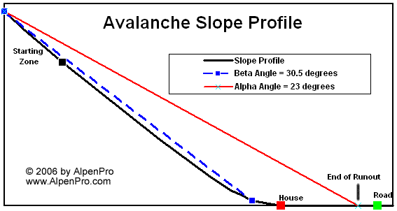
Before going out on a tour that could bring me close to some overhead hazard I use caltopo to estimate how far a slide might run. First I draw a line like this:
Then I look at the profile for that line and click "expand:"
This average angle gives you a good estimate of the alpha angle. You might need to draw a few lines to get it right. Please note that I wrote "good estimate." That's the best you can do. It's useful info, but don't bet your life on it (just like you shouldn't put excessive trust in slope angle shading). You can also export those lines as a .gpx file and reference them in any mapping app on your phone. This lets you check how close you are to potential runouts as you're skinning up, even if you can't see what's above you.
The above example is from Mount Trelease in Colorado where a snowboarder was buried and killed last February. If he had transitioned lower down, instead of proceeding up on to the flat bench under the face, he would be alive:
To measure alpha angle in the field you can sight along an inclinometer to the start zone. This gives a good estimate too. Note that precision is tricky here, so err on the safe side, especially if danger is high, or if you're setting up a tent.
I prefer to use an android app called Dioptra (there is a similar iphone app called Theodolite). These are camera-based navigation tools. When you open the app you see a view through your phone's camera with cross hairs in the middle. On the right side you see the angle at which your phone is tilted up or down. Here is screenshot example using a painting of a mountain in my living room:
So, if you aim the crosshairs at a start zone and look at the that number on the right side (16.5 degrees in my screenshot) you know the angle from the start zone to where you are standing. If it's less than 18 degrees you're in good shape (assuming you identify the start zone correctly). I've heard people say they use 22 degrees under more typical avy conditions (as opposed to when those 100 year slides are possible). I don't know what sort of research there is to back that number up.
Stay safe out there.
-
12-18-2021, 05:35 PM #5
 Old Man and the Ski
- Join Date
- Apr 2007
- Location
- Tahoe
- Posts
- 16,325
weird that i new that spot was from the trelease zone even though my only experience with the mountain was the thread here (or in slide zone) last year
powdork.com - new and improved, with 20% more dork.
-
12-20-2021, 12:51 PM #6
 Slow uphill, ugly down
- Join Date
- Jan 2017
- Location
- NW WA
- Posts
- 336
The Poleclinometer has a line for the alpha angle - I'll use it to get a quick idea before selecting a spot for transitioning or taking a break.
-
03-27-2025, 10:34 AM #7
 Registered Abuser
- Join Date
- Mar 2005
- Location
- Yonder
- Posts
- 22,528
Bump for a term I had never heard. Runout? Yes. Should be called runout angle. But now that I know the term “alpha angle” I understand it’s the same way of saying the same thing
Kill all the telemarkers
But they’ll put us in jail if we kill all the telemarkers
Telemarketers! Kill the telemarketers!
Oh we can do that. We don’t even need a reason
-
03-27-2025, 01:00 PM #8
 Registered User
- Join Date
- Dec 2004
- Location
- Where the sheets have no stains
- Posts
- 23,901
Coreshot wants to switch industry standardized language/nomenclature because???
https://www.americanavalancheassociation.org/swagI have been in this State for 30 years and I am willing to admit that I am part of the problem.
"Happiest years of my life were earning < $8.00 and hour, collecting unemployment every spring and fall, no car, no debt and no responsibilities. 1984-1990 Park City UT"
-
03-27-2025, 01:19 PM #9
 FOG
FOG
- Join Date
- Aug 2014
- Location
- the LCC
- Posts
- 1,251
I laughed.
Time spent skiing cannot be deducted from one's life.
-
03-27-2025, 01:30 PM #10
 #tedbundy
- Join Date
- Mar 2005
- Location
- Denver, CO
- Posts
- 6,912
Here's a detailed report from a slide back in 2013 off Loveland Pass where alpha/runout angle was an important factor.
https://snowbrains.com/full-caic-rep...rado-saturday/
Report from Lou Dawson on it:
https://wildsnow.com/9980/sheep-cree...he-site-visit/Ski edits | http://vimeo.com/user389737/videos
-
03-27-2025, 02:28 PM #11
Registered User
- Join Date
- Apr 2024
- Posts
- 69
I don't really understand why people say they're not a useful tool in the field. I'm pretty conservative and would like to be away from runouts as much as possible, but as mentioned, it's really hard to go anywhere (in steeper mountains ranges like the Sierra) without being in 18 degree runouts. So alpha angles seem like a good way to quantify how bad of a runout one is in? I haven't looked enough into how consistent the alpha angles of avalanches in the same time/region are. It's fun to look at slopes and try to estimate your alpha angle, anyways.
-
03-27-2025, 02:30 PM #12
Registered User
- Join Date
- Apr 2024
- Posts
- 69
Also, is there a good tool to do something like alpha angle shading? OnX is developing it, but they only have it for some areas.
-
03-28-2025, 06:32 AM #13
 mutant
- Join Date
- Nov 2002
- Posts
- 9,536
This subject has come up a lot in the last couple of years in classes I've taken and conversations I have had. The idea that the theoretical max runout is defined by physics (alpha angle) is very valid. My unscientific analysis is that experienced and knowledgeable BC skiers tend to underestimate runouts. Many well used and traditional safe zones at the bottom of lines are in theoretical run outs and are at risk.
The challenges to iplementation of the Alpha Angle concept are:
There is not one agreed upon angle
It is difficult to measure safely and well in the field
Observations such as flagged trees underestimate the climax avalanche path
I'm not the mapping expert there are tools in OnX, Gaia, CalTopo etc. that can be helpful in trip planning the the reoccuring caveats of not overly relying on technology.
So my takeaway that is harder done that said it that if it feels like maybe the safezone should be pushing into the trees or down the creek and up the bank on the otherside or so far out into the flat that companion rescue would be additionally challenging or that my view of the next skier is obscured...yeah do that.
-
03-28-2025, 09:05 AM #14
*NOT* an expert
- Join Date
- Oct 2003
- Location
- 9,300ft
- Posts
- 22,979
Time limited:
Alpha angle max varies by climate zone, but there are other variables and exceptions.
The question about path estimation is one of your current cycle. Are you having 5yr climax slides? 10yr? Longer? What do conditions say? What does the forecaster say?
If you are subalpine and under threat of 5+ year climax slides, then flagging isn't a reliable indicator of path. Trees may not be a reliable indicator of path, especially if you are having 10+ year climax slides. Now you are looking at those 18 or 19 deg or whatever your area calls for, especially if you want to do things like move large groups, camp, have a PZ/LZ, or a picnic. And that is how I explain alpha utility to students and rescuers.
When you are in that type of cycle is when forecasters switch to saying "don't be anywhere near avalanche terrain," which should get your hackles way up especially if it is risk 3. That is very different advice from "don't be in avalanche terrain or connected terrain" that might otherwise be given in risk 3-4 situations. Originally Posted by blurred


 Reply With Quote
Bookmarks