
this was the funnies staged slash turn rock hit photo shoots I have ever seen. Nice work gentlemen...Originally Posted by mc_roon


Results 251 to 275 of 951
Thread: Wasatch Conditions 09-10
-
01-08-2010, 12:09 AM #251
 Registered User
- Join Date
- Feb 2009
- Posts
- 29
-
01-08-2010, 11:24 AM #252
 wordsmith
- Join Date
- Oct 2003
- Location
- SLC
- Posts
- 6,255
Got out for a dawn patrol Thursday, very good skiing and fun snow. When I made this turn, my partner felt the entire slope collapse and saw a crack shoot across the entire slope. No bueno. We got really lucky on this one.
 I'm so hardcore, I'm gnarcore.
-
01-08-2010, 02:26 PM #253

 searching for downtime
- Join Date
- Aug 2005
- Location
- in the brew room
- Posts
- 2,396
dp this morning in upper lcc. dropped a small cornice on east facing with no results. east facing trees were fast and creamy. south facing was super silky. will prob be baked by tomorrow?
-
01-08-2010, 02:34 PM #254
 chasing the white whale
- Join Date
- Aug 2008
- Location
- Two Thousand Leagues
- Posts
- 1,014
One cornice on N-facing, one ENE. Originally Posted by TeleThor

-
01-08-2010, 02:40 PM #255
 Dork.
Dork.
- Join Date
- Feb 2007
- Location
- Not Philly
- Posts
- 4,476
Posted in the thread bitching about the conditions in the Wasatch:
if you look at the ensemble forecasts for the PNA/AO and NAO you see a change in the current values for each of the models sometime after the middle of next week. This indicates that conditions favor the detoriation of the current ridge. While it is unclear whether a trough or zonal pattern will develop, the chance of snowfall increases significanly in as you move towards the last 10 days of jan.
The GFS ensembles support this solution as the majority show increased precipitation in beginning with the 18-22 time frame and then larger scale systems from the 24th onward. The 500mb height forecast is similar and while there is considerable spread timing of systems the GFS has been holding steady with decreased heights in the 270hr to 384hr time frame.
The Euro has been fairly consistent also with the depiction of decreased heights in this range.
Two issues to be aware of for the wasatch:
1. Systems splitting with a large core of pacific energy diverging south to the AZ/NM/So. Colo. area. Very possible in this el nino set up
2. Cut off low. The death of Utah snow. If a low were to cut off and linger just off the cali coast as is possible in these patterns that would be bad. I don't see it happening but it's possible for sure.
One other interesting note:
I wrote this fall that is ENSO winter was very similar to the ENSO events of 2006-2007 and 2004-2005. Jan. 2007 was Alta's worst month in the last five years. (Feb was really good and march too). I lost the data for jan. 05.
Just wanted to throw this in:
HPC (NWS long range weather arm) seems to agree that in the 8-14 day range we'll see a noticable change in the orientation of the Pac. Jet
Via HPC:
THIS SUGGESTS TEMPERATURE AND PRECIPITATION
PATTERNS OVER THE CONUS WILL BE QUITE SIMILAR BETWEEN THE TWO PERIODS. THE MODELS SUGGEST THAT 500-HPA HEIGHTS WILL AVERAGE CONSIDERABLY LOWER OVER MOST
OF THE WEST COAST OF THE CONUS THAN IN THE 6-10 DAY PERIOD. THIS INDICATES THAT THE STRONG PACIFIC JET IS FORECAST TO PROGRESS EASTWARD BETWEEN THE 6-10 AND 8-14 DAY PERIOD. IT IS STILL A BIT EARLY TO PREDICT THE STRENGTH AND ORIENTATION OF THE PACIFIC JET AS IT IMPACTS THE WEST COAST. MOST MODELS PREDICT THE JET WILL MAINLY IMPACT CENTRAL CALIFORNIA AND THE CENTRAL GREAT
BASIN. HOWEVER, STRONG EL NINO CONDITIONS ARE CURRENTLY OBSERVED, WHICH FAVORS A SOUTHWARD DISPLACEMENT OF THE JET, SO THE PROBABILITY OF ABOVE MEDIAN PRECIPITATION IS ELEVATED SLIGHTLY FARTHER SOUTH OF THE AREA MOST TOOLS INDICATE. TEMPERATURES IN CALIFORNIA EASTWARD TO THE CENTRAL AND SOUTHERN ROCKY MOUNTAINS ARE UNCERTIAN SINCE THEY ALSO DEPEND ON THE ORIENTATION OF THE PACIFIC JET. NEAR NORMAL TEMPERATURES APPEAR MOST LIKELY AT THIS TIME, HOWEVER THE CHANCES OF BELOW NORMAL TEMPERATURES INCREASE MARKEDLY IF THE JET SETS UP FARTHER SOUTH THAN MODELS CURRENTLY INDICATE.Last edited by lionelhutz; 01-08-2010 at 03:15 PM.
-
01-08-2010, 03:22 PM #256
chasing the white whale
- Join Date
- Aug 2008
- Location
- Two Thousand Leagues
- Posts
- 1,014
lionelhutz- where's that discussion from?
-
01-08-2010, 03:30 PM #257
Dork.
- Join Date
- Feb 2007
- Location
- Not Philly
- Posts
- 4,476
The first part before the NWS is from my dome.
The NWS part is from:
http://www.cpc.ncep.noaa.gov/product...ay/fxus06.html
it comes out at 3pm EST every day but weekends.
Additional medium range products are available here via the HPC discussions:
http://www.hpc.ncep.noaa.gov/html/discuss.shtml
A premilinary discussion covering D 1-3 usually comes out overnight (EST) and the Longer range up to D-7 comes out early morning (EST). The get revised into final forecasts but nothign changes.
I've wanted to expand my utarded weather knowledge recently so I might be throwing some weather forecasts up here to see how I do. I've worked up my Northeast (mainly NY/VT) knowledge pretty well and since I love the LCC/BCC i'd like to get better at forecasting there.
-
01-09-2010, 01:36 AM #258
Registered User
- Join Date
- Sep 2007
- Location
- Cottonwood heights
- Posts
- 123
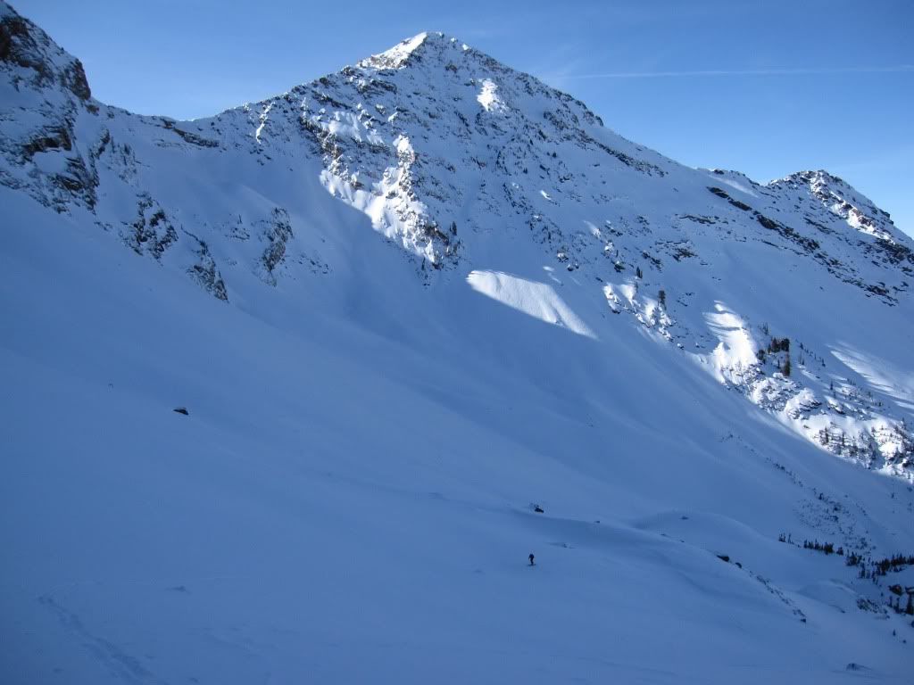
I skid the South Face of Mount Superior today from the peak. First descent of the season. It felt solid.. Some wind loading on the peak, but manageable. Snow off the top variable, wind hammered in spots. Middle apron was money. Sick Run.
-
01-09-2010, 01:57 AM #259
Registered User
- Join Date
- Sep 2007
- Location
- Cottonwood heights
- Posts
- 123

-
01-09-2010, 11:14 AM #260
 Registered User
- Join Date
- Oct 2007
- Location
- on the mountian
- Posts
- 1,408
^shoulda skied it off the summit.
-
01-09-2010, 11:26 AM #261
Registered User
- Join Date
- Sep 2007
- Location
- Cottonwood heights
- Posts
- 123
very summit does not go yet
-
01-09-2010, 11:54 AM #262
 Hiding in AK
- Join Date
- Oct 2003
- Location
- Was UT, AK, now MT
- Posts
- 14,568
Then it wasn't a "first descent of the year". Originally Posted by cravenmoorehed


-
01-09-2010, 12:51 PM #263
Registered User
- Join Date
- Sep 2007
- Location
- Cottonwood heights
- Posts
- 123
We skid off the summit down the ridge and dropped in a little lower then the top. If you want to get technical, whatever, still a bad ass run.
-
01-09-2010, 05:12 PM #264
Hiding in AK
- Join Date
- Oct 2003
- Location
- Was UT, AK, now MT
- Posts
- 14,568
I could really care less. I was just jabbing you a little. Originally Posted by cravenmoorehed
-
01-09-2010, 08:03 PM #265
 Registered User
- Join Date
- Feb 2006
- Location
- LCC
- Posts
- 326
Been skiing NW-W faces the last couple days. From around 8.5-11,000'. Snowpack isn't very interesting. Except everywhere I dig, I always find these on the bottom:

Still good turns to be found. Just ask Boissal...

-
01-09-2010, 08:11 PM #266
 Registered User
- Join Date
- Dec 2009
- Location
- Portland
- Posts
- 478
Anyone hit Meadows today? calling for 40 and sun tomorrow...could be a spring day!? (Without the winter snowfall)
It will start snowing Tuesday...I'm heading back to Chicago until the following Tuesday. Everyone enjoy the POW and post lots of pics.
-
01-10-2010, 05:56 PM #267
Dork.
- Join Date
- Feb 2007
- Location
- Not Philly
- Posts
- 4,476
I think you'll all see some mild precip the middle of the upcoming week and then as you head into the 20-22nd time frame a trough will dig in the west. As storm roll into cali, plenty of energy will spread into the trough and bring precip to the great basin. Now it's far too early to talk amts but numerous impulses will be spreading through the west. Coupled with the trough you have to like the potential for these impulses to steadily raise the snow depth.
-
01-10-2010, 06:47 PM #268
Hiding in AK
- Join Date
- Oct 2003
- Location
- Was UT, AK, now MT
- Posts
- 14,568
Wind crust, powder, facets. Variable conditions on high elevation east aspects and lower elevations as well today, but fun anyway.


-
01-10-2010, 07:05 PM #269
User
- Join Date
- Oct 2003
- Location
- Ogden
- Posts
- 9,806
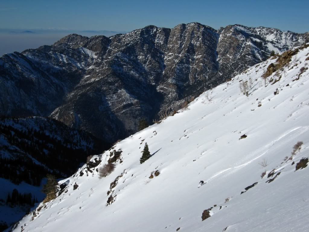
I found variable like TH. The best turns were mid elevation, SW facing. I wanted to climb some rock and we did but we realized that getting back down on the rime covered rocks was going to be interesting so we didn't get the peak. If you need a character building experience the exit out Broads Fork is a good start. Good day.
feeling small:
a few good turns:
-
01-10-2010, 08:41 PM #270
Hiding in AK
- Join Date
- Oct 2003
- Location
- Was UT, AK, now MT
- Posts
- 14,568
No, but I'll leave you with this. Originally Posted by the Mad


-
01-11-2010, 01:03 PM #271
chasing the white whale
- Join Date
- Aug 2008
- Location
- Two Thousand Leagues
- Posts
- 1,014
To the guys who Bear Grylls'ed it up in Twin Peaks Wilderness in Mill B South on Fri night: THIS SUCKS.

I appreciate simple shelters and snow camping, but this is a sorry job. Felling trees, especially live ones to build a shelter that's too tall to ever hold body heat and then defoliating other trees to keep your ass off the snow is sad. Temps went went down to what? 20 degrees on Fri night? Was that really necessary? Dont worry, I used my sandwich bag to carry out your cigarette butts and I'll use that shitload of p-cord you tied those trunks together with for something useful. "If you dont know a knot, tie a lot..."
-
01-11-2010, 01:33 PM #272
 "touring guy"
- Join Date
- Jan 2009
- Location
- SLC burbs
- Posts
- 4,429
Holy shit that must have taken some work... They could have found 6 different ways to the car in the time it took them to put that monstrosity together.
Too bad they weren't trampled by a moose in the middle of their gnar gnar adventure night.
-
01-11-2010, 01:37 PM #273
Banned
- Join Date
- May 2007
- Location
- Sandy, Utah
- Posts
- 14,408
Wow yeah thats pretty fucking lame right there....glad you picked up after them...jesus a winter sleeping bag and a vapor barrier wouldve been enough this weekend....thats almost bigger than my house. Originally Posted by The Gnarwhale
-
01-11-2010, 01:38 PM #274
Registered User
- Join Date
- May 2008
- Posts
- 37
You didn't need to do that. The butts would disappear into the woods come spring. The cans from our pork and beans might not though. Maybe you should have grabbed them. They were buried in about the same spot we buried our shit Originally Posted by The Gnarwhale
 , 20 yards or so uphill from the shelter.
You didn't happen to see a camouflage poncho around there anywhere, did you? My buddy Stan got kind of wasted and went running up the hill to go sled on his poncho. He came back, but the poncho didn't.
Sorry you didn't like our shelter. I thought it was awesome.
-
01-11-2010, 03:34 PM #275
Dork.
- Join Date
- Feb 2007
- Location
- Not Philly
- Posts
- 4,476
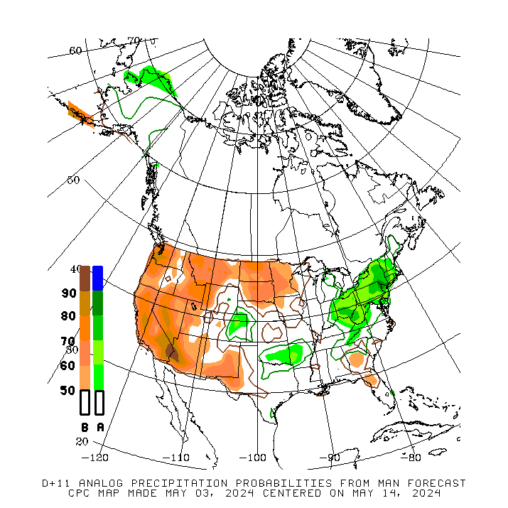
Still on track for development of western trough and increased precip for 2nd half of january.
Long story short:
Moist energy will head into the great basin wed-thurs. NWS says it splits but model data doesn't exaclty confirm that. 700mb rh values are high as upper level energy passes over great basin after the weakly split front passes on wed. This should allow for a longer duration precip event and may negate the splitting front.
After that days 6-10 see stronger energy impacting Cali and then spreading moisture west into the entire sw.
From then on it appears the west will remain much more active with above normal precip from the Nor Cal/NV/UT border southward.
NWS: ABOVE-MEDIAN PRECIPITATION AMOUNTS ARE MOST LIKELY FOR THE GULF AND SOUTHERN
ATLANTIC COASTS DUE TO AN EXPECTED ENHANCED LOW LATITUDE JET. THE GFS AND
CANADIAN MODELS CONTINUE TO SUGGEST ENHANCED CHANCES OF ABOVE-MEDIAN
PRECIPITATION AMOUNTS NEAR THE UPPER MISSISSIPPI VALLEY. ABOVE MEDIAN
PRECIPITATION AMOUNTS ARE FAVORED ALONG THE WEST COAST FROM OREGON SOUTHWARD,
AND INLAND THROUGH THE GREAT BASIN AND MUCH OF THE SOUTHWEST. THE CHANCES FOR
ABOVE MEDIAN PRECIPITATION AMOUNTS ARE ESPECIALLY ELEVATED IN SOUTHERN
CALIFORNIA.
d 8-14:
THE MODEL FORECASTS FOR THE WEEK-2 PERIOD ARE VERY SIMILAR TO THE 6-10 DAY MEAN
SO THE TEMPERATURE AND PRECIPITATION PATTERNS OVER THE CONUS ARE ALSO SIMILAR.
THE MODELS SUGGEST THAT 500-HPA HEIGHTS WILL AVERAGE LOWER OVER MOST OF THE
WESTERN CONUS THAN IN THE 6-10 DAY PERIOD. THIS INDICATES THAT THE STRONG
PACIFIC JET IS FORECAST TO PROGRESS EASTWARD BETWEEN THE 6-10 AND 8-14 DAY
PERIOD, RESULTING IN ENHANCED CHANCES OF ABOVE MEDIAN PRECIPITATION OVER MUCH
OF THE CONUS.
And while I'm not a huge believer in analog weather forecasting, I think this bears some considertion. The analog precip patters for the 8-14 day period based on current and forecasted condtions:


 Reply With Quote
Bookmarks