Mother Nature to Deliver Some Much Needed Pow to the Sierra
Popular Stories

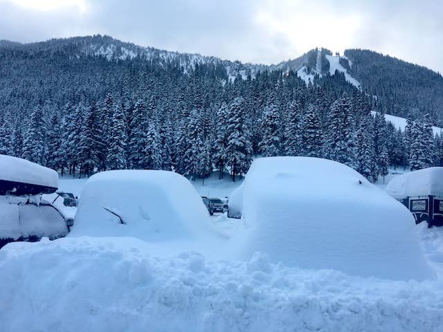
 Stevens Pass, Washington caught a cool 36 inches in 48 hours. Powderchaser Steve photo.
Just when you thought the Sierra was dead, most ski areas of Northern California will be crushed with several game changing storm systems by the end of next weekend that will dump 3-5 feet of fresh pow on mountains in the Golden State.
The first storm is moving in Monday, and through Tuesday a foot or more should fall on most resorts in the Tahoe Basin. Areas further south, including Mammoth, will see lighter amounts. There is a break in the action on Tuesday before a much stronger system approaches from the Pacific Northwest on Wednesday night. That system will bring significant snowfall to most of the Sierra that could last through Saturday. The firehose is will stay open until late this weekend and possibly even longer with a cooling trend.
The storms come on the back of significant snowfall across much of the Pacific Northwest over the past two days. In the past two days alone, Stevens Pass pulled down 36 inches, Alpental caught 30 inches and Crystal also saw 30 inches of the white stuff.
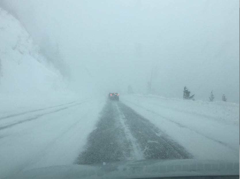 Stevens Pass in whiteout form on Sunday. Photo: Powderchaser Steve
But it isn't just the Pacific Northwest that has scored recently.
10-12 inches fell in the Cottonwood Canyons in Utah in the past few days and it’s snowing currently in Jackson, Wyoming with more snow to come. Snowbasin surprised everyone with 13 inches overnight last Thursday while Wolf Creek and much of southern Colorado nabbed 2-4 feet last week after a rough early season. Most of Idaho, Wyoming, Oregon, Washington and Utah have potential to see significant snow in the next five days, especially beyond midweek.
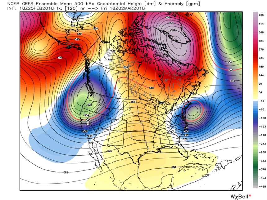 Upcoming storm systems through Friday. WeatherBell photo.
But, as stated, the Sierra will be the real star of the upcoming week. Heavy snow will be falling Thursday morning with the bullseye almost directly over Lake Tahoe. It’s possible the front stalls over the northern Sierra early Thursday before slowly progressing south towards Mammoth Mountain by Friday morning. You may be able to nab double digits on Thursday at Kirkwood, Squaw or any of the northern resorts and chase the same storm to Mammoth for Friday. Snow will lighten somewhat over the northern Sierra Friday morning before increasing by afternoon. Heavy snow will be falling once again over Lake Tahoe late Friday and Saturday. That storm may favor northern resorts as well. Colder temperatures will drop the snow level to Lake Tahoe later Thursday and into the weekend. Most resorts will receive decent low elevation snow especially later Thursday-Saturday. Some rain is possible at lake level Wednesday night or early Thursday.
Sign Up for the TGR Gravity Check Newsletter Now
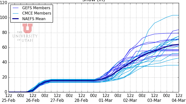 University of Utah Plumes ensemble showing a wide range of solutions on snow totals for areas around Donner Pass (Interstate 80) in California. The average is the dark blue line at about 60 inches by the end of the week. The wide spread of ensembles members indicates the uncertainty beyond March 1st. University of Utah photo.
With the second round of storms several days out, the details still need to be worked out. My confidence is high for significant snowfall for much of the Sierra Range. Amounts could trend higher or lower as we get closer to the weekend forecast.
While it will be snowing into Saturday for most of the Sierra, a good portion of moisture this week will be aimed at the Wasatch, southern and central Idaho, Wyoming, and isolated areas of western Montana. It’s likely the Wasatch and Tetons, perhaps even southern Idaho, see decent accumulations this week. Look for deep snow for those areas by Thursday/Friday, in addition to the solid totals some areas have received on Monday.
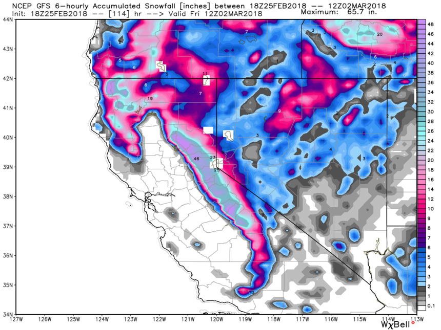 Total snowfall through Friday morning. WeatherBell photo.
Looking to the long range, it's unlikely that high pressure returns to the Sierra for at least the next two weeks. I have some confidence that some additional systems may impact this region beyond the next seven days. Although the Sierra has been struggling mightily all winter, it looks to end February and begin March with a bang! Lets hope it continues!