The Western Winter Switch-Flip: Regional Snow Totals and the Week’s Forecast
Popular Stories

The weekend’s biggest story, hands down, was the massive storm that slammed the Sierra Nevada. The highest peaks got buried under nearly three feet of heavy, early-season snow. It’s a huge base-builder for California, and a clear sign that winter is back. Now, the system is shifting east. The action moves to the Rockies and the Pacific Northwest next. We’re cutting through the noise with the snow forecast you need for Montana, Wyoming, Colorado, and Utah.
Montana & Wyoming: The Northern Reach Awaits
We have a major, on-the-ground report from the Northern Rockies: Winter is here, and it showed up with a vengeance. Over the past 24 hours, the Tetons and Southern Montana got absolutely hammered.
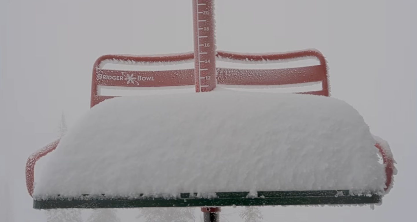
Grand Targhee Resort, in the Tetons, was one of the big winners, picking up 5-to-12-inch of fresh snow. This is a significant, high-quality base-builder that has coated the entire mountain in fresh powder. Likewise, up in Montana, Bridger Bowl near Bozeman logged 10 inches on the stick this morning. These numbers confirm that the early-season hype is fully justified for the region. With this swift, deep drop, the region moves out of the 'on-watch' category and directly into the action.
The Outlook: A Foot-and-a-Half More on the Way
The Northern Rockies are far from finished. Following a short, sunny break on Monday, the forecast is calling for an incredibly active pattern. In the Tetons, models are showing steady snow chances, with a high-impact storm likely midweek. Grand Targhee's extended forecast points to heavy snowfall starting Thursday, with some models calling for up to 18 inches by Sunday. Farther north, Bridger Bowl and the Bozeman area mountains also have multiple shots at snow this week, with Thursday shaping up as the next big hit. As totals build, it’s important to keep an eye on local avalanche reports.
The California Cascade Snow Forecast
The Sierra Nevada is the clear epicenter of this storm. A Winter Storm Warning covered the range through the weekend and into Monday. Forecasters expect heavy accumulation, one to three feet of snow in higher elevations.This kind of early-season blast in October is rare for Southern California. Naturally, it’s grabbing the attention of everyone who lives for winter.
Travel has become extremely difficult. Meteorologists warn of near-impossible driving conditions and visibility dropping to a quarter-mile. Strong wind gusts, reaching up to 70 MPH, are compounding the danger. At lower elevations, the system is bringing widespread rain instead. That’s welcome news, offering critical relief to drought-stricken areas in the southern third of the state.
Washington & Oregon: PNW Power-Up Awaits
The Pacific Northwest has moved beyond the dusting stage, it’s officially stacking snow. Cold moisture is ramping up quickly, delivering deep conditions for early-season turns.
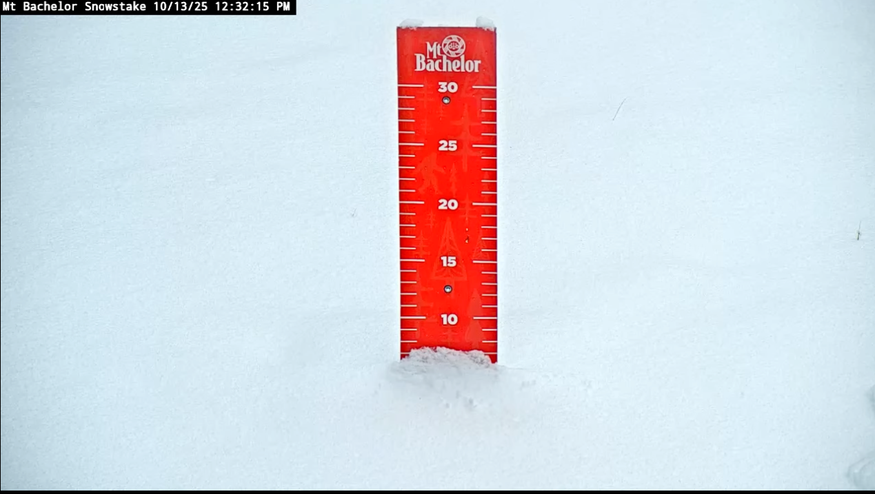
In Oregon, Mt. Bachelor is currently reporting 7 inches on the stick at mid-mountain. This significant total provides a massive jumpstart for the Central Oregon resort.
Our Newsletter
In Washington, the snow kept falling through the night. To start, White Pass received a crucial 2 to 4 inches yesterday, and reports indicate it was still dumping deep into the evening — a nice mid-October refresh. At the same time, Crystal Mountain picked up a fresh dusting and is currently reporting continued snowfall. Now, as the system tracks east, freezing levels are dropping fast. This shift favors the North Cascades, where higher terrain could see 8 to 14 inches of accumulation. All in all, it’s the kind of early-season push TGR lives for — time to get those touring setups ready.
PNW Forecast
The extended pattern heavily favors the PNW. This region has a strong probability for above-normal precipitation for the remainder of October, with forecasts indicating that the North Cascades could be staring down 6-12 inches as the freezing levels continue to drop. The cold air needed for a major event is finally sinking into the mountains. As we head into the rest of the week, keep those big mountain dreams alive and watch those snow trackers closely—the atmosphere is finally aligning for the coastal powder you know and love.
Colorado & Utah: A Welcome First Coat
The Central Rockies saw their crucial initial snowfall event, setting the stage for opening day.
In Utah, the buzz remains strong. A few Utah resorts, including Brighton, saw small, isolated dustings of a couple of inches. This first coat is the crucial foundation for the deep winter we all live for, allowing mountains to commence snowmaking with confidence.
Meanwhile, Colorado has seen similar success at its higher elevations, with minor snow events reported in areas like the San Juans. While they didn't receive the foot-plus totals of the Northern mountains, these initial accumulations are vital for freezing down exposed terrain and preparing for the next wave.
The Outlook
Utah mountains will see periodic chances for high-elevation snowfall through the middle of the week. Specifically, the Wasatch is due for a cold-air refresh, with mountain towns like Park City potentially seeing a light dusting of snow or sleet on Wednesday and Thursday (1.4, 2.5). The cold temperatures, with lows dropping into the 20s at altitude in areas like Snowbird and Park City, are the real win here. This ensures that any snow that falls sticks, and it allows snowmaking operations to fire up as resorts eye their opening dates.
This aggressive early-season push across the Western US is an undeniable signal that winter has arrived, much earlier than expected in many regions. With the PNW and Northern Rockies already posting significant snow totals and forecasts calling for up to 1.5 more feet for the Tetons, the core ski and ride areas are setting up for an exciting start to the season. The message is clear: the snow guns are firing, the cold air is locked in, and the time to prep your kit and plan your first trips is now.