Andrew McLean on the Shelf Life of Guidebooks in the Digital Age
Popular Stories

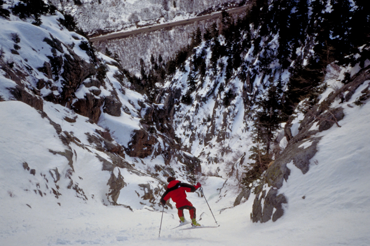 Steep skiing in the Wasatch, relatively unchanged in the last 20 years. Andrew McLean photo.
As much as we all love the spirit of exploration when it comes to backcountry skiing, let’s face it: without a good guidebook we’d probably still be skiing the same old zones right close to home. 20 years ago, a guidebook for the Wasatch first came out that soon became a cult classic, and still today provides inspiration countless backcountry skiers and snowboarders. Andrew McLean’s steep-skiing bible The Chuting Gallery has become a cult classic and the go-to guidebook for skiing gnarly lines in the mountains above Salt Lake City, ad has even become the grounds for an extreme game of “who can ski it all?”
TGR caught up with McLean, who still lives, works, and skis in the Salt Lake City area, to chat about where it all got started and the future of guidebooks in the age of the internet.
TGR: It’s been 20 years since you first published The Chuting Gallery, what sparked the idea to create a guidebook for your home mountains?
Andrew McLean: I was born in Salt Lake CIty, then actually moved away, and grew up in Seattle, skiing at a place called Alpental. It’s got a lot of steep runs, gnarly terrain, which made me used to skiing steep lines from an early age. In addition, I also started rock climbing, so by the time I moved back to Salt Lake in 1990, I was interested in steep skiing and rock climbing. I hadn’t really done much backcountry skiing at that point, because at the time in the U.S. that really only meant tele-skiing. It meant learning a new turn, getting weird gear, and it was really just this weird tree-hugging existence. Soul patches. Moustaches. That type of thing.
About that time, I met Alex Lowe, the legendary climber. He was the guy who kind of turned me on to ski mountaineering and backcountry skiing could be. I told him I wanted to ski Alta’s main Baldy Chute, and I was really thinking of waiting until the resort opened and doing it all like that. It was still October, but Alex, of course said “Oh yeah! Let’s go do it tomorrow morning before work!”
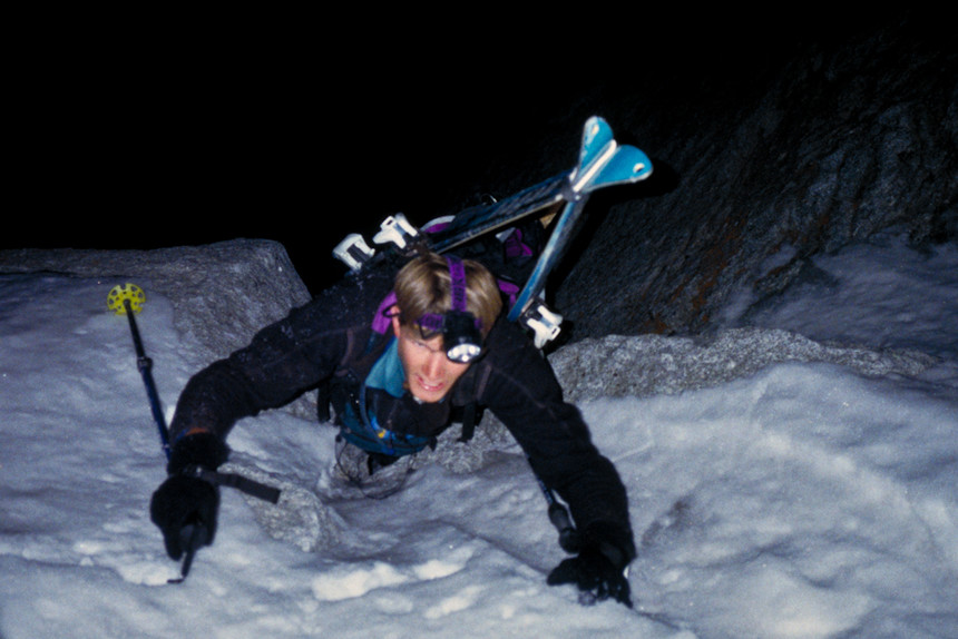 Early morning ascents were crucial to exploring what the Wasatch had to offer. Andrew McLean photo.
TGR: How’d it go?
AM: So we did it, and it didn’t take that long, especially with Alex breaking trail up there. We made it to the top right at sunrise, and the whole thing was knee-deep powder the whole way down. That one really set the hook for me. From there, we started looking around for similar stuff in the area. Alex knew about some of these bigger lines in the area, like the south face of Superior, so we started skiing these things together. At the top of each one of them, you would look over and see about a hundred more things to ski within a short walk.
So that’s where the real impetus for the book came from, just kind of standing up there and realizing that there was several lifetime’s worth of skiing to be had in such a small area.
TGR: Where did you come up with the list?
AM: It really was mostly me just going out and skiing lines and taking notes about aspect, elevation, angle, and things like that. I was familiar with that kind of format from all the rock climbing guidebooks I had studied. They keep track of all those things, and of course include a rating system for climbs. In terms of grading these ski descents, a system actually already existed at the time. I talked to Lou Dawson and kind of used his, and in retrospect I wish I had kind of changed it. Basically, it was grade 1-6 was easy, grade 7 was extreme ski mountaineering terrain, and grade 8 was this impossible grade of mountaineering objectives. It was really subjective, in that there was nowhere to go in terms of getting any harder.
So the list really got started with me talking to the Utah Department of Transportation guys, the guys that shoot the guns to control Little and Big Cottonwood canyons. I was shown a book in the Alta guard station, that had maps of all the control areas. They had done this amazing aerial encyclopedia of all of these chutes, things like Tanner’s and Argenta chutes that UDOT had to control. When I saw it, I asked if I could borrow it and made copies of it. That was like half of my book right there!
TGR: How many of them were first descents for you?
AM:The Wasatch is such a tight range with such a large population around it, so I didn’t even try to get into first descents. Unlike the Tetons, with a long approach and tight community with a history of reporting climbing and skiing accomplishments, in the Wasatch it’s pretty hard to find out who did things first, you just go out and ski stuff.
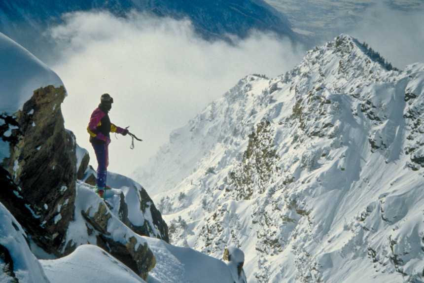 Standing atop peaks in the Wasatch led the McLean finding ever more lines to ski. Andrew McLean photo.
TGR: At what point did you decide that your list was done?
AM: The beauty of it was that it was kind of open-ended for me. There was no set date for finishing or a set number or runs. In retrospect, it occurs to me that I was giving away too many secrets back then! At least, there’s a lot of them out there that aren’t in the book. I had worked on for at least three years, and it finally felt that I had done enough work.
I had originally planned on just self-publishing the book, printing out pages on 8.5” by 11” pages, and stapling them together. I thought I would print out something like 20 at a time, since back then the market was so small. But by the time I printed it out, it turned out to be 100 pages, way too thick to put a staple through! So, I realized I had to find a printer.
Sign Up for the TGR Gravity Check Newsletter Now
Luckily, Salt Lake, with all their Book of Mormon printing, has a huge industry of printing. I went down and found one, and they took my files and printed up the first batch.
The very first edition actually had a typo on the first page. I wrote “forward” instead of “foreword” in large print. I showed it to a friend, who without realizing I was the one who wrote it, said “what kind of idiot misspells the first word in their book?”
TGR: What do you think the future of guidebook holds in the age of social media and the internet?
AM: Call me old-school, but I do really like being able to just flip through a book. The thing with info being on the internet and social media is that you kind of have to know exactly what you are looking for. With a guidebook, you can just kind of flip it open and scroll around to find different areas and see what you want to ski. I think a lot of people just really like having a reference book that they can pick up and look at and see photos and descriptions to get an idea of a zone all in one shot.
What I’ve seen, especially in the Wasatch, is someone posts a picture of say, booting up the Y Couloir in powder, and immediately there’s other people heading that way who saw the post.
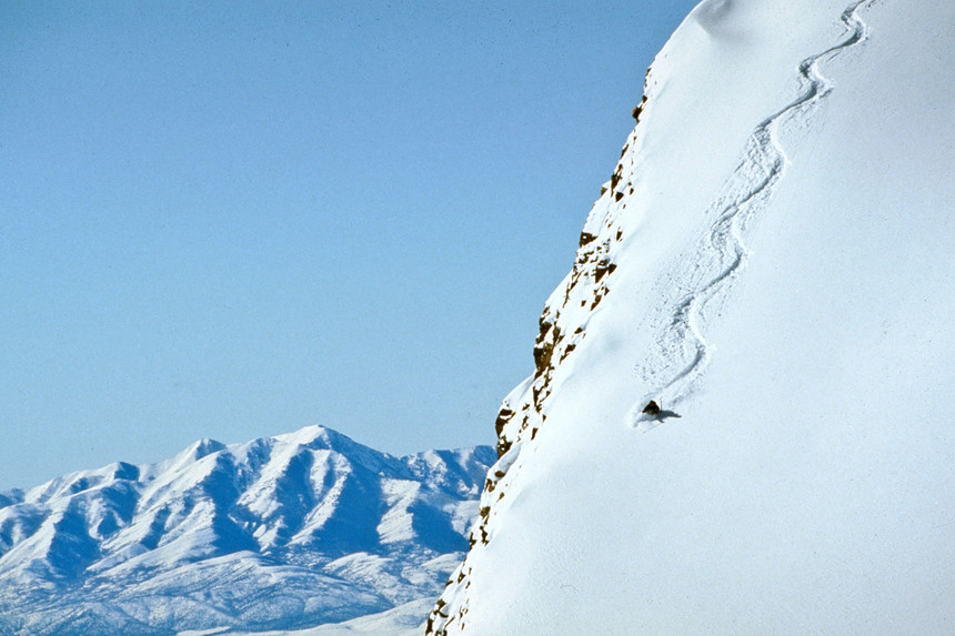 A guidebook can tell you where to go, but not when conditions look as good as this. Andrew McLean photo.
One of the tricky things with backcountry skiing is knowing when to go. A guidebook will just show you where to go and how to get there, but you really need to know when the best time is based on snow, avalanche, and weather conditions. Social media takes that out of the equation, because it is a really powerful tool for sharing real-time conditions, which of course brings way more people into the backcountry.
That being said, there is still a big need for guidebooks, whether it’s a real book or online, to let people know of an entire collection of ski descents.
TGR: What about guarding secrets?
AM: When I first got started, none of that even occurred to me. I started on the book because there were so few people doing that kind of thing. Big obvious lines like the South Face of Superior got skied maybe once or twice a year back then, now it’s more like once or twice a day. It just wasn’t that common. I thought, if I put out this book, maybe 10 more people would get out and ski it. Turns out, I was wrong! I never anticipated the huge boom in backcountry skiing we are seeing now.
On one hand, I think it’s really cool that so many people are getting turned on to it and getting fired up and having that same experience. But it definitely makes it much harder to get fresh tracks out there! It means you have to be much savvier about it. There definitely are a lot more areas out there now where I make sure to crop my photos, so you can’t tell where they are. I definitely don’t use location tags.
In the end, seeing people out there and happy to be sharing the experience of backcountry skiing outweighs the guarding of the secrets. After all, things get out. It might be a secret for a season or two, but eventually people follow the skintrack, circle around the rocks and say “Oh! Check this out!” There goes the secret with or without a guidebook!