Monster Winter Storm to Produce 3-5 Feet of Snow for Thanksgiving
Popular Stories

The snow god, “ULLR” is pretty much celebrating Thanksgiving week in the west! A significant winter storm has consistently been on the weather model runs for several days and continues to explode when looking at several scenarios that may happen next week in the west. The Sierra is likely to grab it’s first deep dump of the season. Valley snow in the lower elevations of Nevada and California is likely mid to late week.
This will be a game changing storm for many areas that have yet to see significant snow. The highest snow totals will fall in the 4 corners followed by the Sierra and Wasatch. Significant snow is also possible into the Tetons and some spots in north/central Colorado, all dependant on the path of the storm.
Folks will be eating white feathers on Thanksgiving Day, especially the Sierra, 4 Corners, extending up into the Wasatch range of Utah, and perhaps the Tetons. The Pacific Northwest will also grab a decent storm as early as next Monday.l Most every region of the west will see snowfall in the next 5-7 days!
On the other hand, a recent blast of powder just crushed the 4 corners region including some areas along I-70 in Colorado.
Reports below are from the last several days.
Arizona SnowBowl - 22 inches
Wolf Creek - 18 inches
Telluride - 16 inches
Ski Santa Fe - 16 inches
Beaver Creek - 11 inches
Confidence in forecasting 5-7 days out is often a struggle when looking at the details of who gets the most snow. Confidence however is very high at this point that the incoming system Thanksgiving week will provide deep snowfall to many areas of the west. Some model runs even show a mean average of 30-50 inches of snow for some spots in northern Arizona and southern Utah.
Abnormally cold temperatures are going to bring snow levels to as low as 3500 feet in the Sierra beginning Tuesday night/Wednesday. Cold air from Canada works its way into a very wide area of the west impacting spots well south into Arizona and New Mexico for the holiday period.
Below: Temps at roughly 9800 feet plunge well below 0-celsius by midweek for most of the west.

Forecast: There are really 2 systems to talk about. The first will bring moderate snow to British Columbia favoring western areas and the North Cascades of Washington late Saturday/Sunday. That system drops quickly into Montana, Tetons and Wasatch Monday night into Tuesday bringing light to moderate snow (3-7). The Wasatch range in Utah is likely to score higher amounts, perhaps 8-12 inches by Tuesday afternoon with unstable NW flow. Colorado is also in the game from some moderate snow favoring resorts along or north of I-70 (4-8).
Storm #2
While the Rockies get teased early week, another system with colder temps and a much higher moisture tap begin to impact the Pacific Northwest on Tuesday (Southern Cascades including most of Oregon). That system drops into the Sierra Tuesday night with heavy snowfall through Wednesday. Models indicate snow showers occasionally moderate at times may continue into the latter part of the holiday week in the Sierra. Peak snowfall will be late Tuesday night and Wednesday.
Below: Snow is ramping up over the Sierra late Tuesday night (Image- Courtesy of Meteostar).

Sign Up for the TGR Gravity Check Newsletter Now
Total snowfall is likely to be in the 14-20 inch range for most of the Sierra with perhaps higher amounts on the southern Crest of Kirkwood and Mammoth. My gut tells me that Mammoth will lead in totals after this storm.
In the 4 corners copious moisture feeds up from the south. The models are indicating ranges between 20-30 inches for northern Arizona and similar amounts for southern Utah. Resorts that are favored will be Arizona Snowbowl, Brian Head, and Eagle Point. Moisture will feed north into the Wasatch of Utah and the Tetons of Wyoming. Resorts favored with S-SW flow in northern Utah are Sundance, Big Cottonwood (Brighton, Solitude) and perhaps Park city or even Snowbasin. Amounts are a bit tricky to nail down this far out but currently it appears that 12-18 inches are possible for northern Utah and 6-12 are a wildcard for the Tetons. Some snow will also work its way into Montana but amounts are likely to be less. If you are chasing White Turkey the highest amounts will be found in the south. Many resorts have opened from the recent storms impacting the southern Rockies so check with your mountains before heading out.
Below: Snow is beginning to crank with impressive moisture feeding into northern AZ and southern Utah late Wednesday into Thursday. You can see moisture extending north into the Wasatch and even the Teton ranges. Montana will also see some snowfall. Image: Courtesy of MeteoStar.

This will eventually reach Colorado by Wednesday night with the heaviest snow late Thanksgiving Day into Friday. Amounts in Colorado will be heaviest in the San Juan range including Wolf Creek and Silverton (2 Feet plus). Telluride is a wildcard. Models show decent snowfall albeit lighter amounts extending north into Crested Butte, Aspen, and even Steamboat who sometimes reaps rewards from the south. Moderate snow will extend along the I-70 corridor towards the Front Range albeit lighter than resorts south or west. New Mexico gets a healthy dose of powder Friday and Saturday (12 plus for Taos).
Below: Snow is cranking heavily in the San Juan Range of Colorado extending north. Peak snowfall is likely going to mid Thanksgiving day and Friday.

Bottom Line: Significant snow will be falling this week, especially with storm #2 that takes a path form the Sierra into the southern sections of Utah and northern Arizona. Moisture feeds north into the Wasatch and perhaps the Tetons later this week. Southern Colorado will get nailed as well Thanksgiving day into Friday. New Mexico is a solid contender late week.
While the models are in agreement this is all going to happen, Im throwing in a disclosure that sometimes as we get even within 72 hours of a storm things can suddenly change. It’s not likely. ULLR is likely to be celebrating his holiday in the West.
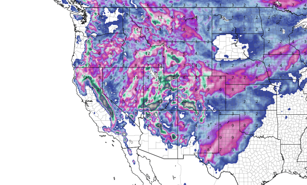
Below: Total snowfall through Friday night for the west that includes both the early week and late week storms. You can see the highest amounts in the dark green or brown colors indicating 3-4 feet in many areas. Image: Courtesy of Tropical Tidbits.

- Powderchaser Steve