
Results 151 to 175 of 324
-
02-19-2021, 08:40 AM #151
 Registered User
- Join Date
- Feb 2008
- Posts
- 2,737
Pssh, I'm going to predict the future right here: the Blazers will not win the NBA championships. There you go, you can send me some beer once my prediction comes true in July. Originally Posted by Benny Profane

-
02-19-2021, 10:29 AM #152

 Registered User
- Join Date
- Oct 2003
- Location
- slc
- Posts
- 17,983
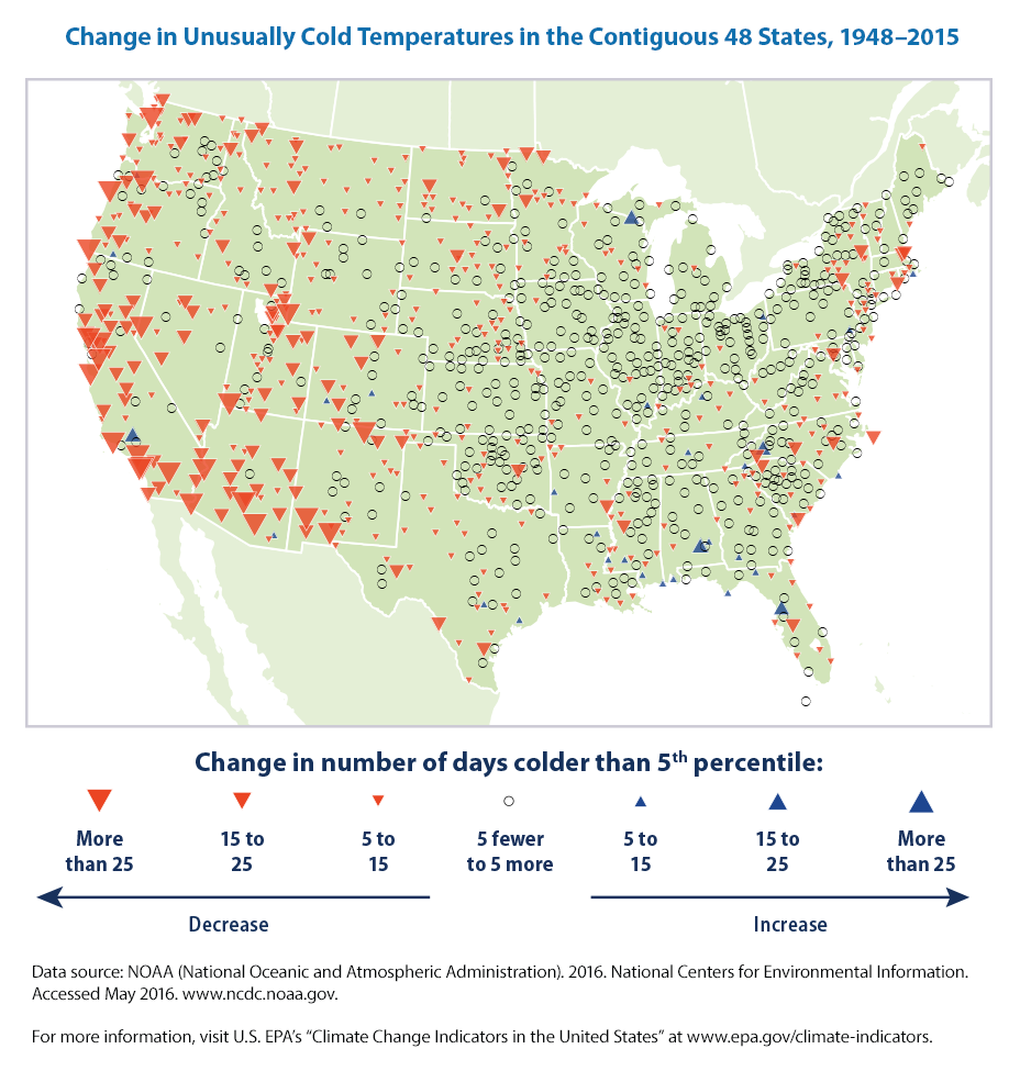
Reading that post it feels like he's arguing against a point that no one is making. He's generally talking about average conditions, not low-frequency events like this one. Even then, east of the Rockies his second figure does not seem to support his conclusion that cold snaps are becoming considerably less frequent. The article he cites that "debunks" the idea that "cold waves are enhanced by a "lazy" jet stream, weakened by global warming" is from 2013 and he's quite arguably misrepresenting their findings. At best, it's not representative of the current scientific consensus. From a 2019 review article published in Nature Climate Change: Originally Posted by The AD
https://www.researchgate.net/publica...winter_weather
Observational analyses support that AA, and in particular sea ice loss, can infuence midlatitude winter weather through a stratospheric pathway. Climatology favours a strong polar vortex supported by cold air over the Arctic and milder air at lower latitudes. This temperature distribution forces low geopotential heights over the Arctic and higher heights in the midlatitudes (left panel of the figure). In recent decades, this climatologically favoured configuration of the polar vortex has become increasingly perturbed 15,70,88,116. Although Arctic warming is strongest at the surface (see Fig. 1 in the text), it extends throughout the mid-troposphere. In addition, the sea ice loss and associated warming is not uniform across the Arctic, but rather regionally focused. Concentration of Arctic warming in the Barents–Kara Seas dilates geopotential heights over northwestern Eurasia, leading to more frequent high-latitude Scandinavian/Ural blocking that is favourable for the excitation of vertically propagating energy associated with large-scale planetary waves9,67,69,88. The increased vertical propagation of energy is coupled with more frequent intrusions of warm air from lower latitudes, depositing heat in the polar stratosphere, which causes a second maximum of Arctic warming where the polar vortex normally resides. Warming throughout the atmospheric column dilates the geopotential heights suffciently to reverse the normal Equator–pole geopotential height gradient, resulting in cold air previously trapped near the pole to be displaced to the midlatitudes. As air flows southward away from the North Pole towards the Equator, the air is deflected to the west by the Coriolis force, forming an easterly wind around the North Pole. The redistribution of air masses that happens first in the stratosphere is then replicated through the troposphere to the surface. This completes the reversal of the NH circulation pattern with relatively warm temperatures and high geopotential heights over the Arctic and lower heights in the midlatitudes accompanied by more frequent cold air out-breaks to the midlatitudes.
The full text of the paper is available through the link.
Now, that said, I'll certainly concede that certain parts of the media are almost certainly overplaying and/or mischaracterizing this relationship. Hype machines gonna hype and "GW may increase probabilistic likelihood of Texas cold snap from 100-year event to 30-year event" isn't exactly an attention-grabbing headline. There are probably many, many more climate change deniers out there claiming that the Texas crisis disproves anthropogenic GW entirely. I'm shocked Ron Johnson hasn't materialized in this thread to say just that.
NASA predicted the future with astonishing precision and accuracy yesterday. I can tell you with >99.99% certainty that in 10 million years the southern coast of California will be hundreds of miles to the north of where it is now, and that there will be an oceanic channel through East Africa. Where's my money? Originally Posted by neufox47
-
02-19-2021, 10:40 AM #153
 Bugs
Bugs
- Join Date
- Oct 2003
- Location
- Seattle
- Posts
- 27,359
I think you can concede that there are many more red arrows on the map than there are blue ones, though. Originally Posted by Dantheman
-
02-19-2021, 10:57 AM #154
Registered User
- Join Date
- Mar 2008
- Location
- northern BC
- Posts
- 31,043
BTW ted was born in Canada but they moved when he was 4 and then he became an American citizen 5 yrs ago so if he is all fucked up it was whatever influences from living down there Originally Posted by char_
Lee Lau - xxx-er is the laziest Asian canuck I know
-
02-19-2021, 11:38 AM #155
Registered User
- Join Date
- Oct 2003
- Location
- slc
- Posts
- 17,983
In the West the trend is obvious, not so much in the Midwest and East. Regardless, I'm not sure that dataset is an appropriate one to use for very low-frequency extreme events. That NCM article clearly does not support what he's saying, and the older article he cites doesn't "debunk" anything, it only says the mechanism appears to be more complex than some researchers have suggested. Originally Posted by The AD
-
12-27-2021, 01:46 PM #156
 A bitter little fruit
- Join Date
- Nov 2002
- Location
- EWA
- Posts
- 22,013
12 degrees.

Last edited by KQ; 12-27-2021 at 02:16 PM.
“When you see something that is not right, not just, not fair, you have a moral obligation to say something. To do something." Rep. John Lewis
Kindness is a bridge between all people
Dunkin’ Donuts Worker Dances With Customer Who Has Autism
-
12-27-2021, 02:35 PM #157
 Registered User
- Join Date
- Dec 2012
- Location
- I can still smell Poutine.
- Posts
- 24,678
You should head over to Lewiston. Downright tropical.
-
12-27-2021, 02:35 PM #158
 Registered User
- Join Date
- Dec 2004
- Location
- Where the sheets have no stains
- Posts
- 22,168
+3 here today, might be the daytime high.
I have been in this State for 30 years and I am willing to admit that I am part of the problem.
"Happiest years of my life were earning < $8.00 and hour, collecting unemployment every spring and fall, no car, no debt and no responsibilities. 1984-1990 Park City UT"
-
12-27-2021, 02:54 PM #159

- Join Date
- Mar 2008
- Location
- the ham
- Posts
- 13,385
Doubt grrr still reads this forum, but it was -1 F on the dollar lot's thermometer this am.
8 was the low at my house last night. Balmy 16 and sunny now.
-
12-27-2021, 03:13 PM #160
 expert in residence
- Join Date
- Sep 2008
- Location
- Geopolis
- Posts
- 16,171
it got up to -16F in Calgary today. that’s cold but what’s annoying is that people on the canadian radio were talking about -50, i thought “huh, that’s notable” but it was of course just windchill. clickbait everywhere!
j'ai des grands instants de lucididididididididi
-
12-27-2021, 03:22 PM #161
Registered User
- Join Date
- Dec 2012
- Location
- I can still smell Poutine.
- Posts
- 24,678
What's up with people in Canada going with the wind chill number? My daughter does that. Of course it's always windy in Fredericton and she walks to campus, but still. It's annoying.
-
12-27-2021, 03:24 PM #162
Registered User
- Join Date
- Dec 2012
- Location
- I can still smell Poutine.
- Posts
- 24,678
And it was in the single digits above zero here in snow Albans last week. Wasn't so bad.
-
12-27-2021, 03:28 PM #163
expert in residence
- Join Date
- Sep 2008
- Location
- Geopolis
- Posts
- 16,171
i find single digits to be fine too as long as it was negative the day before. funny how that works
j'ai des grands instants de lucididididididididi
-
12-27-2021, 03:29 PM #164
 Used Register
- Join Date
- Sep 2001
- Location
- Before
- Posts
- 28,021
It was 9F this morning on Union Hill, Lower Snoqualmie Valley.
Merde De Glace On the Freak When Ski
>>>200 cm Black Bamboo Sidewalled DPS Lotus 120 : Best Skis Ever <<<
-
12-27-2021, 04:34 PM #165
- Join Date
- Mar 2008
- Location
- the ham
- Posts
- 13,385
Same reason they measure their dicks in centimeters Originally Posted by riser3
-
12-27-2021, 04:51 PM #166
Registered User
- Join Date
- Dec 2012
- Location
- I can still smell Poutine.
- Posts
- 24,678
Ding! Ding! Ding! We have a Weiner! Originally Posted by Ted Striker
-
12-27-2021, 04:54 PM #167
 Steezus Christ
- Join Date
- Dec 2005
- Posts
- 11,220
It’s a not subtle humble brag when the windchill numbers gets quoted
Riser that campus being built on a slope is a death trap once it becomes icy
-
12-27-2021, 05:07 PM #168
 Last Survivor of the NPG
- Join Date
- Aug 2007
- Location
- At the beach
- Posts
- 19,152
I get the daily Sun Peaks update. It was -35 in the valley today. That is to fuckin cold to even consider for this jong.
That is why I like dogs, more than most people. Originally Posted by leroy jenkins
-
12-27-2021, 05:51 PM #169
 On the Underhill Account
- Join Date
- Mar 2006
- Location
- General Sherman's Favorite City
- Posts
- 35,348
Every time someone mentions cold and Calgary my mind instantly brings up the image of John Candy leaving the Calgary airport in Cool Runnings Originally Posted by ml242
I still call it The Jake.
-
12-27-2021, 07:43 PM #170
 Do I smell Bacon?
- Join Date
- Sep 2010
- Location
- Shuswap Highlands
- Posts
- 4,354
We woke to -33C at 450m up the valley from Sun Peaks. A little colder in Blue River and Valemount. Didn't even start the vehicles today, daughter took great humour in my frosted beard after walking the hound. Got to -21C at 13:00. Took all the XC skis in and doubled up the cold blue glide wax - these temps are with us for a couple more days yet. Hound is happy, she doesn't mind the temps, but knows she gets warm meat & bone broth when the mercury dips below -20C. Coldest its been here at this time of year since they started the weather station in 2014; can't remember it being this cold at Yuletime since I moved here in 2008. Originally Posted by liv2ski
Many local social media posts showing the record highs of 47C in June, down to minus mid-30's 6mo later. Crazy times.Last edited by BCMtnHound; 12-27-2021 at 11:06 PM.
-
12-18-2022, 01:45 AM #171
A bitter little fruit
- Join Date
- Nov 2002
- Location
- EWA
- Posts
- 22,013
Looks like it's going to be a tad chilly in W2 next week.
Welcome winter!“When you see something that is not right, not just, not fair, you have a moral obligation to say something. To do something." Rep. John Lewis
Kindness is a bridge between all people
Dunkin’ Donuts Worker Dances With Customer Who Has Autism
-
12-18-2022, 09:55 AM #172
 Registered User
- Join Date
- Dec 2010
- Location
- Last Best City in the Last Best Place
- Posts
- 7,333


-
12-18-2022, 11:15 AM #173
Registered User
- Join Date
- Nov 2006
- Location
- idaho panhandle!
- Posts
- 9,981
Ambient or wind chill? That’s cold man!
Sent from my iPhone using TGR Forums
-
12-18-2022, 11:22 AM #174
Registered User
- Join Date
- Dec 2004
- Location
- Where the sheets have no stains
- Posts
- 22,168
Moving to Montana sooooon.
MTZ326-182300-
Gallatin Valley-
Including Bozeman and Gallatin Gateway
257 AM MST Sun Dec 18 2022
.TODAY...Mostly cloudy. Highs 15 to 20. Southwest winds up to
10 mph.
.TONIGHT...Colder. Partly cloudy in the evening then becoming
mostly cloudy. Lows 5 below to zero. South winds up to 10 mph.
.MONDAY...Mostly cloudy. A 20 percent chance of snow in the
morning. Highs 10 to 15. West winds up to 10 mph. Wind chill
readings 5 below to 15 below zero.
.MONDAY NIGHT...Mostly cloudy. Lows 5 below to zero. West winds
up to 10 mph.
.TUESDAY...Mostly cloudy. Slight chance of snow in the morning,
then chance of snow in the afternoon. Highs 10 to 15. West winds
up to 10 mph. Chance of snow 40 percent.
.TUESDAY NIGHT AND WEDNESDAY...Colder. Snow likely. Light snow
accumulations. Lows 5 below to 10 below zero. Highs around
5 above. Chance of snow 70 percent.
.WEDNESDAY NIGHT...Much colder. Mostly cloudy with a 20 percent
chance of snow. Lows 25 below to 30 below zero.
.THURSDAY...Partly cloudy. Highs 5 below to zero.
.THURSDAY NIGHT...Not as cold. Mostly cloudy with a 40 percent
chance of snow. Lows 10 below to 15 below zero.I have been in this State for 30 years and I am willing to admit that I am part of the problem.
"Happiest years of my life were earning < $8.00 and hour, collecting unemployment every spring and fall, no car, no debt and no responsibilities. 1984-1990 Park City UT"
-
12-18-2022, 12:20 PM #175
Registered User
- Join Date
- Dec 2010
- Location
- Last Best City in the Last Best Place
- Posts
- 7,333
That be ambient. Lol. We'll see if it actually gets that cold. I think it will depend on how far that arctic front dips to the south. Originally Posted by 2FUNKY
You guys are projected to be on the southern tip of the front. You could catch a break. Big Sky forecast seems a tad warmer even. Originally Posted by Bunion 2020
In any case the woodstove is going to get a workout this week.

 Reply With Quote
Bookmarks