
Results 1 to 25 of 62
-
05-15-2011, 02:37 PM #1

 Because I'm a caveman....
- Join Date
- Oct 2008
- Location
- NorCal
- Posts
- 2,573
Mega TR: Evolution Loop (inc. Goddard and N. Couloir on Lamarck)
Dates: Tuesday, May 10 – Friday, May 13, 2011
Skiers: Enginerd & UCL
Photos: Enginerd & UCL (as noted)
Synopsis: Over a four day period in between weather windows, Enginerd and I completed the classic High Sierra ski tour, the Evolution Loop. In addition to the classic tour plan, we added in side trips to Mt. Goddard and the North couloirs on Mt. Lamarck. The Evolution sub-range of the Eastern Sierra is considered by many to be one of the most beautiful areas of the entire Sierra. During our four days on the tour, I would consider this belief to stand true.
DAY 1 – LAKE SABRINA TO ECHO LAKE
The first day of the classic approach to the Evolution Loop begins at Lake Sabrina at 9,218 ft and travels approximately six miles to Echo Lake at 11,602 ft for the first night’s camp.
Leading up to our tour, Enginerd and I were a little concerned about the weather. This spring, the weather in the High Sierra has been very inconsistent, to say the least. Short periods of high pressure have generally been book-ended by brief periods of low pressure, cold temps and snow. Heading into the four day tour, the weekend prior had brought a low pressure system with light winds, but the chance for up to 6 inches of new snow. The forecast then called for generally stable weather during the week with cool temps (for Spring) and a possible second system coming in the following weekend.
After stopping at MoMart on Monday night and discussing conditions with a friend who had skied Esha Peak that day, Enginerd and I headed into the tour with conservative minds to check out conditions up by Echo Lake before heading deeper into the backcountry. We wanted to be sure little snow feel and conditions were stable before climbing the steep Echo Col on Day 2.
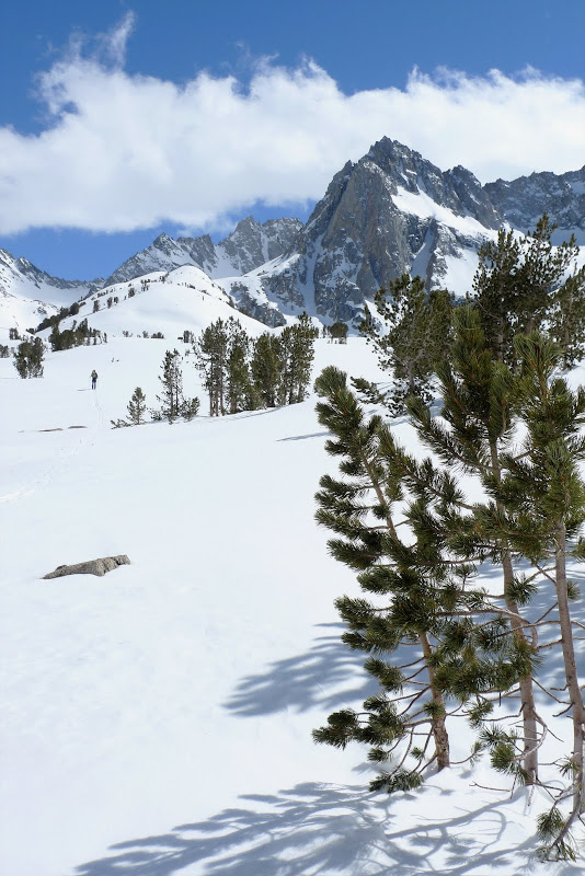
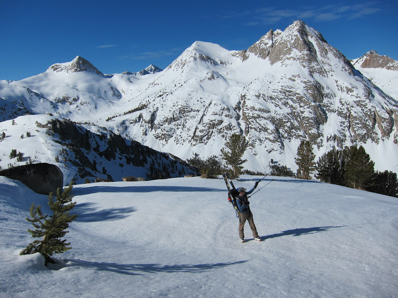
The road to Lake Sabrina is entirely plowed and open to the lake. We arrived at Lake Sabrina with parting clouds as the brief weather window started to push out the exiting system. Photo: UCL

The route around Lake Sabrina brings you to a steep climb up to several drainages that lead to Echo Lake. After the initial climb, we were greeted by our initial glimpses of the High Sierra. Photo: UCL

Interestingly, the forecast for the next four days called for pretty cold temps (highs in the low 30s), but we never found that to be the case. Day-time highs all appeared to be in the 40s. Coupled with the strong sun and clear skis, traveling conditions were warm but great.
UCL chilling while eating a snack, taking in the amazing views. Photo: Enginerd

Skin-track stoke as Enginerd heads up. Enginerd and I generally traded breaking trail pretty evenly during the entire tour. Photo: UCL

Enginerd working towards Echo Lake, with Mount Haeckle way off in the distance. Photo: UCL

Working up over Topsy Turvy Lake towards Clyde Spires. Photo: UCL
UCL with Mount Haeckle in the far distance. Photo: Enginerd

The final push towards Echo Lake. Photo: UCL

Our camp at the end of Day 1 at Echo Lake Echo Col moves up beyond the lake and up around the corner around Clyde Spires. Photo: UCL

DAY 2 – ECHO LAKE TO WANDA LAKE
On Day 2, we climbed over Echo Col (12,540 ft) and headed around five and a half miles to Wanda Lake. In the morning, we headed up Echo Col after assessing snow conditions to see how much snow the area received over the weekend. We did not find any evidence of instability and the area only appeared to receive a couple of inches of snow without wind. It appeared the brunt of the weekend storm impacted more North of our tour area.
The early morning conditions made for quick boot packing up to Echo Col. Here, UCL heads up to the pass. Photo: Enginerd

Enginerd follows up to Echo Col. Photo: UCL

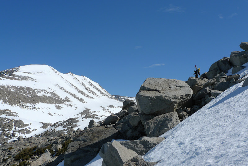
Unfortunately, the back-side of Echo Col was not fully covered for a ski descent. Here, I down-climbed to check the conditions and see if we could get beyond the crux. Photo: Enginerd

We found a good route through the constriction and down-climbed with our packs. Photo: Enginerd

After putting on our skis, we had a nice 2,000 ft descent before beginning our climb towards Muir Pass.
Enginerd heads down. Photos: UCL


UCL enjoying the down on the apron below Echo Col. Photo: Enginerd

As we continued down, we were treated to awesome views of the Black Divide (on looker’s left) and Mt. Solomons in the far distance. Photo: UCL

Enginerd pushing along the next bench above the second half of the descent, with Echo Col high behind him. Photo: UCL

Enginerd continues on. Photo: UCL

UCL following down at the bottom of the descent. Photo: Enginerd

As we began our climb up to Muir Pass, the Black Divide towered overhead. And UCL pushes along. Photos: Enginerd


On our way up, we saw the only other people out in the region the entire trip. A group of two was making some great tracks down Mount Solomons. (and later Black Giant) Photo: UCL

We continued our way up to Muir Pass and the John Muir Hut built by the Sierra Club for emergency shelter for hikers on the John Muir Trail. Photo: UCL

After a quick rest outside the Muir Hut, we headed down some low angle terrain to our camp at Wanda Lake. Enginerd heading down. Photo: UCL

The terrain around Wanda Lake was surreal. Photo: Enginerd

UCL digging out our mid tent in the distance. Photo: Enginerd

Enginerd checking out the clouds at our camp on Day 2. Photo: UCL

Good times at dinner! Photo: Enginerd

The sunset on night 2 was amazing. Photo: UCL

-
05-15-2011, 02:39 PM #2
Because I'm a caveman....
- Join Date
- Oct 2008
- Location
- NorCal
- Posts
- 2,573
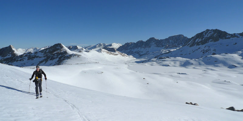
DAY 3 – WANDA LAKE TO MOUNT GODDARD TO THE EVOLUION LAKES AND DARWIN BENCH
Day 3 was a pretty big day. We woke up at 5 AM with the intention of leaving most of our heavy gear at camp and heading with day packs out into the Ionian Basin to summit and ski Mount Goddard. We would then return to camp, pack up the rest of our gear and head up the Evolution Lakes basin to the Darwin Bench. We ended up climbing around 4,500 ft, descending 5,000 ft and traveling 13 miles.
First light crossing Wanda Lake. Photo: UCL

UCL heading up our first climb. Photo: Enginerd

Enginerd checking out a cirque. Mount Goddard is the high peak with the snowfield off in the far distance. Photo: UCL

Enginerd heading up, with the Evolution Basin far off below. The long chain of ridge ending with the flat peak is Mt. Darwin. Photo: UCL
UCL following up towards Wanda Pass, our gateway into the Ionian Basin. Photo: Enginerd

At the top of Wanda Pass, we were treated to amazing views of Ionian Basin – considered to be some of the most remote terrain in the Sierra. The tall peak on the left is Charybdis and across to the right is The Three Sisters and Scylia.Photo: UCL

UCL and Enginerd discussing some travel options. Rather than dropping all the way into Ionian Basin, we traversed one at a time across the SE facing slopes towards Mount Goddard to maintain our elevation. Photo: Enginerd

The Three Sisters are gnarly! Photo: Enginerd

On the way to Mount Goddard, we saw this peak off in the distance which we dubbed “Bizzaro Mount Conness.” The similarity was striking. Photo: Enginerd

After the crest, we headed down on a brief descent before our climb up to the summit of Mount Goddard. Photo: UCL

Enginerd breaking trail along the ridgeline towards Mount Goddard’s summit. Photo: UCL

UCL following the climb. Photo: Enginerd

Enginerd on the final boot pack to the top of Mount Goddard (13,566 ft). Photo: UCL

UCL on the final push. Photo: Enginerd

Enginerd on the summit. Photo: UCL

USGS summit marker. Photo: UCL

UCL posing down on the summit of Mount Goddard. Photo: Enginerd

The snow on Goddard was amazing from top to bottom on close to a 2,000 ft descent. Here, Enginerd drops in from the summit. Photos: UCL

Enginerd ripping down the middle face. Photo: UCL

UCL enjoying the descent. Photo: Enginerd

Enginerd pushing down on the final descent. Photo: UCL

The snow was awesome – as my grin clearly evidences. Photo: Enginerd

Looking back up the face, UCL following Enginerd. Photos: Enginerd & UCL, respectively


After a climb back up, we checked the snow conditions on the SE face to see how much warming they received. Comfortable with the snow, we traversed over one at a time back to Wanda Saddle to avoid having to drop into the Ionian Basin. Photo: UCL

On the front side of Wanda Saddle, we had a great descent right down to our camp. Enginerd heading down at high speed. Photo: UCL

UCL pushing down towards Wanda Lake. Photos: Enginerd


Skiing right back to camp. Photo: Enginerd

At this point, it was only mid-day so we decided to push camp up to the Darwin Bench. That would put us in striking distance for Mount Darwin or Mount Lamarck the following day.
Enginerd skating along Wanda Lake. Photo: UCL

Looking back up our last descent. Wanda Pass is on looker’s left of this unnamed peak. Our tracks work down the face and through the rocky chute at the bottom. Photo: UCL

The backside of Mount Darwin and the high crest above the chain of Evolution Lakes. The John Muir Trail travels through here in the summer. Simply amazing scenery. Photo: UCL

Enginerd looking out to Mount Huxley.

UCL pushing along. Photo: Enginerd

Last edited by Unfrozen Caveman Lawyer; 05-16-2011 at 06:27 PM.
-
05-15-2011, 02:41 PM #3
Because I'm a caveman....
- Join Date
- Oct 2008
- Location
- NorCal
- Posts
- 2,573
Somewhat duplicative shots, but this was quite simply an amazing area. Photo: UCL

UCL with Mount Spencer and Mount Huxley in the distance.

The last push to our camp in the Evolution Basin just below Darwin Bench. Photo: UCL

We dug out the mid and just had a nice dinner outside in warm temps and amazing views. Photos: UCL


It was our first night finally with totally clear skies. The stars were in full force. Photo: UCL

After the moon dropped away. Photo: UCL

The Milky Way was amazing! Photo: UCL
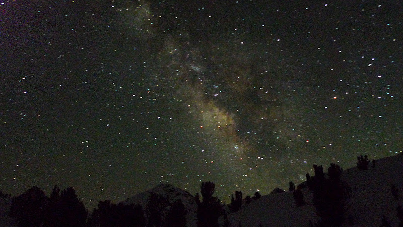
This was my favorite night with an awesome camp. Photo: UCL

DAY 4 – DARWIN BENCH TO MOUNT LAMARCK NORTH COULOIR TO NORTH LAKE
Once again, we woke up early with the goal to push towards Darwin and make the decision on whether to ski the North Couloir/Face on Darwin or push along to Lamarck.
The early morning snow made for each booting up the Darwin Bench. Photo: Enginerd
Enginerd working through Darwin Canyon. Photo: UCL
Mount Mendel, with the steep alpine climbs of the Mendel Couloirs. Photos: UCL & Enginerd, respectively


The North Face of Mount Darwin on the left, with the North Couloir cutting across to the upper left. Photo: Enginerd

We arrived at the turn towards Darwin around 10:30 AM. While skiing Darwin was a possible option, we realized that if we ascended and skied it, we would not be back down until mid-afternoon. In order to move outside of Darwin Canyon, you need to climb to Lamarck Col, a steep, rock-filled South face. We decided that climbing Lamarck Col that late in the afternoon would not be safe, so an ascent of Darwin would require us to camp another night at Darwin bench.
Unfortunately, the last weather forecast we had received on Monday night called for some weather to move in that night. While the forecast was quite dated and the skies were relatively clear, the winds were picking up somewhat and we debated the unknown of the weather.
Ultimately, we decided to move on to Lamarck to ski the North Couloir and move to our car waiting at North Lake. We didn’t want to chance the weather. This decision proved to be good in about two hours!
Enginerd moving up Lamarck Col while the snow was still firm for skinning. Photo: UCL

Amazing views from the top of Lamarck Col. Photo: Enginerd

At the top of Lamarck Col, we heard a very loud thunder clap. And then another. Looking back North beyond Darwin, huge thunderheads were developing and heading South along the Owen Valley and Sierra Crest. We quickly realized that (i) weather was moving in and (ii) the snow was warming up.
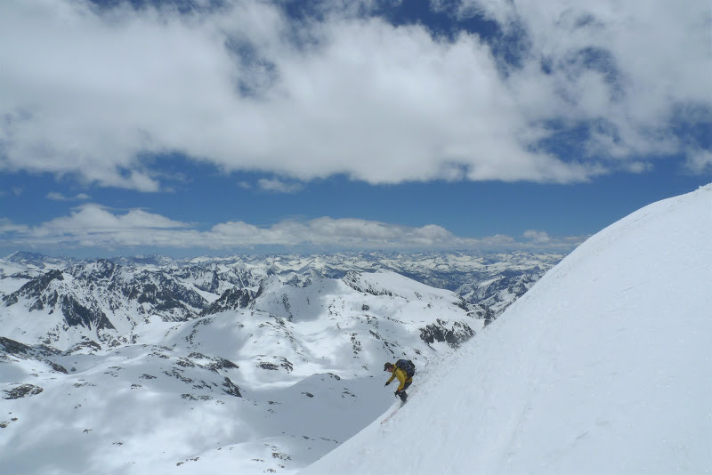
Enginerd broke trail across the East Bowl of Lamarck. Upon following, the skin track kept breaking out due to warming and I slid down about 20 feet at one point. I just decided to forgo the summit and get to the rock band as soon as possible.
This resulted in Enginerd and I skiing two separate couloirs from Lamarck. We decided I would head to the more NE Couloir and watch Enginerd descend the true North Couloir from the summit. When he was at the bottom, he would then watch me ski the NE Couloir.
Enginerd looking down the North Couloir on Mount Lamarck. Photo: Enginerd

UCL coming down the bottom portion of the NE Couloir. There is additional terrain about the rollover on the top. The snow was great, as long as you avoided the wet slide debris from the prior days. It was easily avoidable, though.Photo: Enginerd

Looking back at Mount Lamarck. The North Couloir Enginerd skied is just right of the summit, and the NE Couloir that UCL descended is to the left of the summit, via the left branch of the on the “Y” split up top. Photo: UCL

As the skies continued to darken, we skied all the way down to the North Lake campground. UCL even managing to send some windlip with a heavy pack! Massive backcountry air – haha! Photo: Enginerd

No Eastside trip would be complete without the following key exit factors:
1. Snow bridge river crossings. Photo: UCL

2. Dry river crossings with ski pole vaults. Photo: Enginerd

3. Walking paved roads back to the car. Photo: Enginerd

As a note, the road up to North Lake is still gated as there is some snow in spots, as well as huge boulders from rock fall that will have to be removed.
Upon nearing the car, we quickly realized how our decision to bail on Darwin really paid off. The weather was in fact moving in, and had we gone for Darwin, we would have needed to bail and also forgo skiing the North Couloirs on Lamarck. I guess the message was to trust your gut and go with the prudent decision.
Nearing the car, the thunderheads were dumping rain down in the valley. Photo: UCL

And the upper peaks were completely socked in. Photo: Enginerd

We made it to the car, packed up and started the engine just as the first rain drop fell. Ultimately, an amazing trip with great weather, unreal terrain, a great partner and safe fun skiing!
-
05-15-2011, 02:55 PM #4
Zen Master
- Join Date
- Sep 2001
- Location
- ask the midget
- Posts
- 2,496
Damn fine trip you guys. That scenery is amazing and you really captured the feel of it. Way to get out there and have fun!
-
05-15-2011, 04:13 PM #5
 chasing the white whale
- Join Date
- Aug 2008
- Location
- Two Thousand Leagues
- Posts
- 1,014
Right on! That's a cool traverse. How heavy were your full packs? Looks like you guys were careful about keeping weight down.

-
05-15-2011, 04:22 PM #6
 Me fail english, thats...
- Join Date
- Feb 2008
- Location
- Sunnyvale, CA
- Posts
- 1,361
Wow. Amazing scenery. Almost looks mid-winterish up there. Well played.
-
05-15-2011, 05:04 PM #7
 Type 7 stool
- Join Date
- May 2007
- Location
- Juxtaposition
- Posts
- 5,733
You are a lucky lucky guys. Don't take touring terrain like that for granted, or good multi-day partners. All awesome.
I can almost smell the clear night sky in the star shots.
Been rocking the floor-less pyramid tent myself - a great spring tent for protected areas, I'm a convert (so much so I've been thinking about how I could cut the floor out of a more structurally rigid dome or tunnel type of tent. Another topic)Last edited by neck beard; 05-16-2011 at 06:26 AM.
Life is not lift served.
-
05-15-2011, 05:08 PM #8
 Hiding in AK
- Join Date
- Oct 2003
- Location
- Was UT, AK, now MT
- Posts
- 13,546
Most excellent. I love the Sierra.
-
05-15-2011, 05:32 PM #9
 Jack's got my back
- Join Date
- Jan 2005
- Location
- cb, co
- Posts
- 5,047
too many nice shots (that's a good thing)
-
05-15-2011, 06:00 PM #10
 kind of a big deal
- Join Date
- Oct 2006
- Location
- Home in the Highcountry
- Posts
- 477
WOW! Sweet tour guys! Makes me want to put together a road trip asap.
And as for the unstable weather - fkna dude. Killin' us in Colorado. People have gotten after a few big lines, just have to work the weather windows very nicely.
-
05-15-2011, 06:05 PM #11

 Poundin' coffee and beers
- Join Date
- Aug 2010
- Location
- Garden of Earthly Delights
- Posts
- 137
That is some baller shit right there.
-
05-15-2011, 06:32 PM #12
Lover de La Nina
- Join Date
- Jun 2004
- Location
- South Lake Taco
- Posts
- 983
Great trip. Way to go deeeep.
-
05-15-2011, 07:36 PM #13
fond of graupel
- Join Date
- Dec 2006
- Location
- Boston
- Posts
- 266
That's a tour.
-
05-15-2011, 07:59 PM #14
 SnowTime
- Join Date
- Jan 2006
- Location
- la la land
- Posts
- 5,801
Expansive. Great shots and perfect weather!
`•.¸¸.•´><((((º>`•.¸¸.•´¯`•.¸.? ??´¯`•...¸><((((º>
"Having been Baptized by uller his frosty air now burns my soul with confirmation. I am once again pure." - frozenwater
"once i let go of my material desires many opportunities for playing with the planet emerge. emerge - to come into being through evolution. ok back to work - i gotta pack." - Slaag Master
"As for Flock of Seagulls, everytime that song comes up on my ipod, I turn it up- way up." - goldenboy
-
05-15-2011, 08:11 PM #15
 Registered User
- Join Date
- Dec 2006
- Posts
- 3,711
Great TR, Nick. Looks like a great tour and the photos are great. I love the night shots.
-
05-15-2011, 08:12 PM #16
 Foredeck
- Join Date
- Feb 2009
- Location
- NorCal
- Posts
- 996
Awesome stuff Nick.
-
05-15-2011, 09:31 PM #17
 Old Gaper
- Join Date
- Oct 2003
- Location
- The bleak, beautiful desert
- Posts
- 225
Very awesome. Fantastic night photos. Spent some time in the area and a little to the North in August 2009.
http://www.tetongravity.com/forums/s...esy?highlight=
I saw another TR from that area a week or so ago. Need to get back in the winter.
Thanks for sharing.
-
05-15-2011, 09:48 PM #18
Will work for snow
- Join Date
- Dec 2007
- Posts
- 713
Good stuff.

-
05-15-2011, 11:49 PM #19
 Registered User
- Join Date
- Feb 2011
- Location
- Somewhere...
- Posts
- 221
Amazing! Great pics!
I can't remember...
-
05-15-2011, 11:57 PM #20
Registered User
- Join Date
- Mar 2011
- Posts
- 10
Awesome stuff fellas
-
05-16-2011, 12:08 AM #21
 Registered Nutcase
- Join Date
- Sep 2010
- Location
- Golden, Colorado
- Posts
- 5,871
Killer TR. Loved every image. I need to plan a road trip out that way sometime.
-
05-16-2011, 07:28 AM #22
 Registered User
- Join Date
- Sep 2009
- Posts
- 1,633
that there is a glorious tr...
definitely one of my favorites I've seen...
great conditions, sicktarded terrain, and purty skies for purty pitcher-takin...
-
05-16-2011, 07:30 AM #23
Registered User
- Join Date
- Oct 2006
- Location
- denver
- Posts
- 1,863
Such beautiful country
I can't believe you are a rando racer because I look so much better in Lycra than you.
People who don't think the Earth is flat haven't skied Vail.
-
05-16-2011, 07:41 AM #24
Registered User
- Join Date
- Dec 2007
- Posts
- 285
Very well written up. The mountains speak for themselves but I particularly liked the look of the Wanda Lake area. There's something pleasing about those broad, largely featureless snowfields laid among the crags.
-
05-16-2011, 08:02 AM #25
 Registered User
- Join Date
- Oct 2009
- Location
- Southern NH
- Posts
- 4,286
Killer TR!
The Passion is in the Risk

 Reply With Quote

Bookmarks