3 FEET OF FRESHIES ABOUT TO HIT THE SIERRA!
Popular Stories


The Sierra is sitting at roughly 40-55% of normal currently (Water Content) and is about to wake up to above the kee powder Sunday through Tuesday. It is possible that this storm trumps the largest dump of the season that happened in late December where the National Weather Service recorded 19.5 inches in Tahoe City (December 27-30). This data is kept by the National Weather Service (Lake Level snow). According to OpenSnow Forecaster Bryan Allegretto the biggest dump at a ski area this season was at Homewood with 25 inches on January 17th.
A strong low pressure system is dropping down from the Northwest and hugging the California coast. Colder temps at the lower atmosphere combined with ample moisture pushing against the mountains (Upslope) will bring two to three feet of freshies to the Sierra Ranges through Monday. Chris Johnston from the National Weather Service in Reno states "It’s a cutoff low that with slow movement can produce significant snow especially on Sunday," adding, "The low pressure is going to sit off the coast and continue to pump ample moisture into the mountain ranges.” Temps will stay cold bringing decent snow totals to Valley locations. Even Reno may see some snow by Sunday.
Below: Current Snow water equivalent percent of normal map for northern California showing ranges from 40-53% of normal in most of the Tahoe Basin.

I'm looking at model data, so let me provide you a quick rundown of the most likely scenario to play out for the Sierra.
Light to moderate snow begins during Saturday with strong ridgetop guts (Some lift closures likely). Heavier snow arrives late Saturday night and continues to dump heavily on Sunday. Winds will ease somewhat Sunday. however it’s likely lift impacts are possible from both winds or avalanche control work (Snowing two inches per hour- Breezy at upper elevations).
Below: Moisture totals as of early Sunday morning. Cold Front draped over the north/central Sierra range. Image: Meteostar.

Below: Temps and snow level near 6500 feet on Saturday morning (2-4C in the north and warmer to the south). Temps will lower for Sunday. Image: WeatherBell

Below: Temps fall Saturday night into Sunday bringing snow levels to below Lake Level. Slightly warmer conditions exist in the southern Sierras however higher elevation points near Mammoth will see all snow including Mammoth Lakes with slightly lower totals.

Heavy snow will crank out significant totals primarily on Sunday. Moderate snow and continued AM powder will most likely continue for Monday or Tuesday. Let's look at the latest model runs from both the American and Canadian (We can’t share the European Models).
Sign Up for the TGR Gravity Check Newsletter Now
Below: Total snowfall for the Sierra through Monday morning showing an even spread of 3 feet along the Crest (North to south). This map is at 10:1 (Ratio of snow to 1 inch of water). Colder Temps will improve snow ratios to 15:1 or better so amounts might exceed these levels. Image: WeatherBell

Below: Same map as above compared to the Canadian models showing a peak of 50 inches (This may be overdone however the optimist looks at the trends of all models). The European model is in the 40-inch realm slightly higher than the GFS.

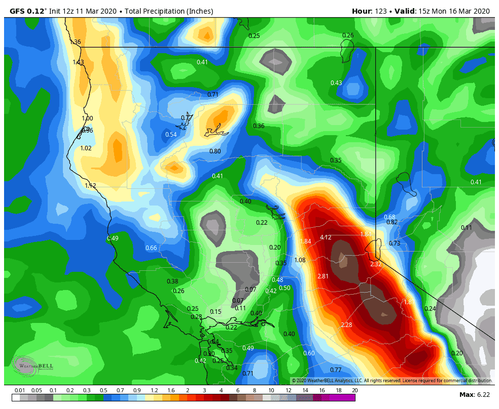
Here is a look at the total water content (Precipitation) through the same period. The southern Sierra (Mammoth) may see slightly less snow, but the difference wont’ be significant. Four to six inches of precipitation is possible with this storm with the highest amounts in the north/central Sierra.
Bottom Line: Finally, the Sierra wakes up to deep freshies, perhaps Sunday/Monday and again on Tuesday ( Light to moderate refreshes). Look for gradual openings of terrain (Avy work in full effect), and several days to score powder. It’s likely that some upper summit terrain stays closed Saturday (Wind) and Sunday (Snow) and opens on Monday or Tuesday as intensity decreases. It will all depend on which mountain you choose of which there will be no bad choice! Expect 10-16 inches at lower elevations and three feet plus above 8500 feet. You can ride pow late Saturday, Sunday, Monday and again on Tuesday. You may even score rope drops as late as Wednesday. It’s about time!
Other spots to chase powder this weekend will be in the Tetons where significant snow will likely fall Saturday PM to Sunday albeit warmer temperatures.
-Powderchaser Steve