
TR: Humbolt, 14,064, 4-29-2007
goldenboy, mtnbikerskierchick
The Sangre de Cristos are a mountain range that has always fascinated me. I've seen them from afar from I-25 and driving on Hwy 160. I remember years ago learning about the history of the San Luis valley, which follows along the Sangres, with it's historic Hispanic cultural heritage. I remember hearing about the land-access issues and environmental debates of the Taylor Ranch and learning that the folks that owned this Ranch in fact owned a whole fourteener. Access to this fourteener, Culebra, was severely limited for years under this owner. Thankfully, the new owner seems to have less restrictions. I remember visiting the Great Sand Dunes, nestled in a corner against the Crestones and thinking that this was a range I needed to explore. I have been happy to find the time this year to experience what this range has to offer.
After the settling of Tuesday's storm, goldenboy and I began to plan for a long weekend's worth of skiing. After nailing Oxford and Belford on Friday (TR on that later), we took Saturday to sleep in (no matter what you're skiing 3 am mornings are never fun!) and to head on down to the Sangres to check out the trailhead for Humbolt. We'd seen Humbolt on our trip the previous weekend to Lindsey, and we were pleased to see that this peak was actually holding snow, which can be a rare sight. After hearing that it had snowed 1-2 feet on Tuesday in the Sangres we were reassured that Humbolt would have good snow.
A view of Humbolt on the way to the trailhead.
It's hard to believe that this valley was full of a foot of snow on the ground only a few days before!
We drove up the road toward South Colony lakes and we were able to make it to the National Forest Boundary. Beyond that the road was covered in snow. We left the snowmobile there, ready for the early morning and went to scope out campsites.
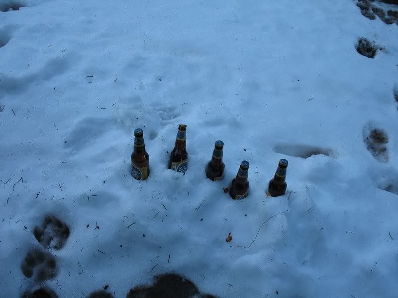
The problem with the South Colony TH is the lack of camping along the road because the road spans miles through private property. On our way to the TH I had seen a sign for another trailhead, Music Pass. So, we followed that sign for a few miles and ended up at the Grape Creek trailhead where we found excellent camping. It even came equipped with a refrigerator:
There was plenty of dead trees around to provide wood for fires. But goldenboy didn't like the smoke
The morning came early once again and we started up the sled in the dark.
Unfortunately, the road was full of obstacles- large patches of dirt and stream crossings. We weren't able to make it as far as we wanted and a final stream crossing put our sledding efforts to a halt around 10,600 ft. So, we dug out the skins and off we went as the sun began to rise.
Our plan was to skin toward the South Colony lakes but then cut up toward the west ridge of Humbolt. We intended to ski the southeast face or east ridge. It wasn't long before we saw Humbolt and then got a great view of the south side. I spotted this line down that looked like it went from the summit. Little did I know we'd end up skiing this line later.
As we rose up out of the valley the views were remarkable. This area is one of the most scenic areas I've seen in Colorado.
Goldenboy skinning with Crestone Needle in the background.
Broken Hand pass
This is why it's called "Broken Hand" pass
My friends happened to be planning a week-long trip to this area as well and we spotted their tents. I never saw them, but we did see their tracks leading toward Kit Carson.
The more we walked to the west side of the mountain, the more the views changed. Lines popped out that were not visible before. Broken hand pass looked like a different place. And there are lines to be had here off of Broken Hand peak. Can you see them?
With the warm temperatures forecasted for the weekend we were worried about the snow not fully freezing over night- hence our reason for choosing the west ridge ascent which usually has less snow than the east ridge. We were pleased to find that above treeline the snow had frozen solid, most likely with help from the clear night skies.
We reached the saddle around 9:30 and headed up the west ridge.
We were rewarded on the summit with spectacular views (and no wind to bother us!)
Kit Carson
Looking down the valley toward Westcliff and the Wet mountains, with Pikes Peak in the background.
The southern Crestones: Lindsey, Ellingwood, and Little Bear can be seen. I think Blanca is hidden.
Of course, the obligatory summit pic
This is the only picture of me you will see in this TR as goldenboy choose to video over stills for the day.
We were pleased to that the summit had decent snow. But time was of the essence. Because we weren't able to get as far on the snowmobile as we had intended, our hike was longer than we wanted. Since we were planning to descend a southeast face with quickly warming temperatures, snow stability was a big concern. The snow coverage on the south east face wasn't as appealing as the snow to the south, skiers right of the exact summit. We knew it led to the south-facing couloir we'd spotted earlier. We opted for that route due to the snow coverage and snow stability.
Goldenboy skiing off the summit.
We had to pick our way through boulders that were scattered about at the top, but you could easily turn between them. In this pic you can see goldenboy's tracks leading through the boulder field. Can you spot him in the pic? (Where's waldo?!!!)
You can see the line opens up into a nice snow field, eventually forming into a couloir.
And some good skiing was had in nice spring snow!
But the day was not over. We still had to contend with getting the snowmobile back to the car, which we were worried about since the snow below treeline had quickly deteriorated with the warming day.
Still, goldenboy wanted to make sure I took pics of his red-necking steeze-- although he resents the fact that I allude to anything he does as beign redneck at allThis stream crossing could not be done without pics
Before we knew it, we were back to the car. But goldenboy further red-necked it by rescuing a couple of Air Force Academy gapers. They'd come up in their big burly truck with NY license plates hoping for a nice hike, not even thinking there would be snow. Well they made one last fatal error of trying to get up a snow patch which sent their truck backwards, slightly off the side of the extremely muddy road. They had tried for a great deal of time to get out of there, resulting in digging a hole that got bigger and bigger. When goldenboy came down with his snowmobile, it was like they'd seen a god- or a redneck who could save them- whichever you prefer
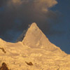
It wasn't long after we'd finished that the afternoon storms started rolling through. A parting shot of Humbolt and Crestone.
I hope I am able to find more time to explore the Sangres again soon!
Results 1 to 25 of 32
Thread: TR: Humbolt, 14,064, 4-29-2007
-
04-30-2007, 10:59 PM #1

 I belong with the snow...
- Join Date
- Nov 2005
- Location
- Where the Butte is Crested
- Posts
- 3,337
TR: Humbolt, 14,064, 4-29-2007
Last edited by mtnbikerskierchick; 05-01-2007 at 12:06 AM.
-
14erskiers.com
"Don't be afraid of the spaces between your dreams and reality. If you can dream it, you can make it so." - Belva Davis
"There are only two ways to live your life. One is as though nothing is a miracle. The other is as though everything is a miracle"--Albert Einstein
-
04-30-2007, 11:03 PM #2
 Outdoorsy Muthafucker
- Join Date
- Dec 2006
- Location
- north of north
- Posts
- 712
sweet shit
-
04-30-2007, 11:59 PM #3
 Registered User
- Join Date
- Dec 2003
- Location
- Jackson, WY
- Posts
- 5,642
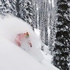
cool angle! I like this shot- you can almost feel the texture of the snow

-
05-01-2007, 12:18 AM #4
 Registered User
- Join Date
- Feb 2005
- Location
- North Vancouver/Whistler
- Posts
- 14,442
gb - you are hauling ass
mbsc - as always you look like a mountain babe.
and i see you are both decked out in Black Diamond Verdicts
-
05-01-2007, 12:42 AM #5
Registered User
- Join Date
- Jan 2004
- Location
- North Vancouver
- Posts
- 6,473
The goldenmtnbikeskier duo is killing it this season.
You guys inspire me to want to go peak bagging. Great work.
-
05-01-2007, 06:25 AM #6
 A. K. A. Yank Mojo
- Join Date
- Mar 2006
- Location
- Just outside the bubble
- Posts
- 1,742
MBSC,
Very nice TR! Lots of great pics, thanks for sharing.Have fun or get hurt bad. "MFT" A.K.A. Dr. Doom
There are but three true sports--bullfighting, mountain climbing, and motor-racing. The rest are merely games. "Ernest Hemingway"
-
05-01-2007, 06:59 AM #7
 Checked out
- Join Date
- Oct 2003
- Location
- CO
- Posts
- 5,017
Great writeup. The snow below the rocks looks nice and smooth. Nice to see the Sangres holding snow still.
-
05-01-2007, 07:09 AM #8
 Caul Fat Dealer
- Join Date
- Sep 2001
- Location
- Alco-Hall of Fame
- Posts
- 2,997
$$$$$$$$$$$$$$$$$$$$$$

$$$$$$$$$$$$$$$$$$$$$$"It is not the result that counts! It is not the result but the spirit! Not what - but how. Not what has been attained - but at what price.
- A. Solzhenitsyn
-
05-01-2007, 07:19 AM #9
 plus size lifestyle model

- Join Date
- Aug 2005
- Location
- WHEREAS,
- Posts
- 12,936
So are you two going to be the first couple to summit and ski all 14ers? The Powder couple strikes again!
 Originally Posted by Roo

-
05-01-2007, 08:44 AM #10
 Think snow
- Join Date
- Oct 2006
- Location
- Zurich, Switzerland
- Posts
- 1,322
Nice TR.
Good to see you guys killing it!
-
05-01-2007, 09:06 AM #11
 Registered User
- Join Date
- Nov 2006
- Location
- colorady
- Posts
- 1,318
I love that valley, I have only hiked it in the summer but we climbed the ellingwood arete to the top of the needle a few years ago. What a sweet spot, you have 4 14ners and a couple great 13ners all at your disposal. Sweet TR.
-
05-01-2007, 09:09 AM #12
 Splitboarders Unite!
- Join Date
- Jun 2004
- Location
- the backcountry
- Posts
- 3,500
Terrain looks awesome, snow looks corntastic....how can you go wrong?
Nice TR!
-
05-01-2007, 10:04 AM #13
Registered User
- Join Date
- May 2005
- Posts
- 4,002
Great TR! Chalk up another one.
It's a beautiful time of the year now when the valleys are greening up and the hills above are full of snow.
-
05-01-2007, 10:16 AM #14
 Jack's got my back
- Join Date
- Jan 2005
- Location
- cb, co
- Posts
- 5,323
Originally Posted by LeeLau
How could you tell I was hauling ass? I wish I wasn't such a video JONG, I would put up the footage of MBSC, she was hauling ass too! The snow was definitely heavy, it was all about getting speed and planing on top.
MBSC ditched her Verdicts a while ago for Mantras. I can't say I blame her. The Verdicts are light, and they're, uh, light!? That's the extent of the good things I can say about this ski.
Thanks for a fun weekend and a great TR, MBSC Humboldt was fun. Looking forward to the Oxford/Belford TR...
And a big shout-out to FrankZappa for letting me park my snowmobile at his place in Salida while we were in the Sawatch. Definitely made my life easier...Last edited by goldenboy; 05-07-2007 at 04:11 PM.
-
05-01-2007, 10:39 AM #15
I belong with the snow...
- Join Date
- Nov 2005
- Location
- Where the Butte is Crested
- Posts
- 3,337
It IS a beautiful time of year! I couldn't stop taking pics Originally Posted by FrankZappa
And LeeLau- yeah, I got rid of my Verdicts back in March. I gave 'em a good chance... skied on them 10 times and tried to get used to them. All in all, they were great in powder, but too soft for me overall. I didn't feel like I could rely on them in mixed/choppy or icy conditions, and when I went fast I could feel them chatter. That made me uneasy so I went back to the Mantras. Sucked it up and paid a pretty penny for the Mantras (although I did get a good deal from the boys at Crested Butte sports- it was just more money than I'm used to paying buying stuff proform). But it was worth every penny. The Mantras just suit me so well. I sold my Verdicts a couple of weeks ago at a gear swap we had at the shop where I work.-
14erskiers.com
"Don't be afraid of the spaces between your dreams and reality. If you can dream it, you can make it so." - Belva Davis
"There are only two ways to live your life. One is as though nothing is a miracle. The other is as though everything is a miracle"--Albert Einstein
-
05-01-2007, 12:15 PM #16
 Seeker of Sastrugi
- Join Date
- Oct 2003
- Location
- The Ranch
- Posts
- 3,792
A well written TR of a not too oft skied peak makes this a joy to behold.
-
05-01-2007, 12:17 PM #17
 poor, ugly, happy
- Join Date
- Apr 2006
- Posts
- 1,792
Nice work MSBC and GB.
Ride Fast, Live slow.
We're mountain people. This is what we do, this is how we live. -D.C.
-
05-01-2007, 12:38 PM #18
 Homegrown Knucklehead
- Join Date
- Sep 2004
- Location
- Fallbroke, SD-CA
- Posts
- 1,641
Very, very niiiice. Your CO season still has many days left in it this year.
peace,
D."There's a truth that sanity denies...." --Sprung Monkey
-
05-01-2007, 12:53 PM #19
 Did it snow last night?
- Join Date
- Nov 2004
- Location
- Eagle, CO
- Posts
- 2,277
Nice work again you guys! My favorite part was the short story about the "red-neckage."
-
05-01-2007, 01:02 PM #20
 Registered User
- Join Date
- Jan 2007
- Posts
- 25
Great TR,
I think the Peaks go like this

-
05-01-2007, 01:41 PM #21
I belong with the snow...
- Join Date
- Nov 2005
- Location
- Where the Butte is Crested
- Posts
- 3,337
Red-neckege is ALWAYS entertaining!!! Originally Posted by Kya
Thanks csteege. I think you're right! Good eye and thanks for labeling them-- something I was far to lazy to do so late last night!-
14erskiers.com
"Don't be afraid of the spaces between your dreams and reality. If you can dream it, you can make it so." - Belva Davis
"There are only two ways to live your life. One is as though nothing is a miracle. The other is as though everything is a miracle"--Albert Einstein
-
05-01-2007, 02:33 PM #22
Caul Fat Dealer
- Join Date
- Sep 2001
- Location
- Alco-Hall of Fame
- Posts
- 2,997
Can anyone answer with the name of the peak that has basically a large flat STEEP W-face? Looks like one side a little further along has a whole bunch of spines you could work? It is almost dead ahead as you drive E out of Sauguache….
"It is not the result that counts! It is not the result but the spirit! Not what - but how. Not what has been attained - but at what price.
- A. Solzhenitsyn
-
05-01-2007, 03:43 PM #23
 Dirty Old Man
- Join Date
- Jun 2005
- Location
- Denver
- Posts
- 2,054
nice looking day. brings back some memories
-
05-01-2007, 06:14 PM #24
Jack's got my back
- Join Date
- Jan 2005
- Location
- cb, co
- Posts
- 5,323
Call me anything other than a redneck! Ahhh! Originally Posted by Kya
Seriously, though, I can't believe I got those idiots out of their mudhole. Tacomas rock!
Lemonboy, I wish I knew the mountain you speak of, it sounds really fun.
This was what the Wet Mountain Valley looked like just days before we got there. (photo Wet Mountain Tribune)

-
05-01-2007, 06:54 PM #25
 Como Estan, Bitches!
- Join Date
- Jan 2006
- Location
- Denver, Co.
- Posts
- 1,422
^ what everyone else said. looks like a great day. I love entering that valley from the wet mtns, incredible views. I may have to try and get some land and cabin in those parts some day....


 Reply With Quote
Similar Threads
-
Widespread "Herring" Panic
By Fritz in forum MUSIC, BOOKS, MOVIESReplies: 223Last Post: 11-07-2015, 01:53 AM -
TR: Chamonix 4/5-4/6
By jumpturn in forum General Ski / Snowboard DiscussionReplies: 8Last Post: 05-02-2007, 08:14 AM -
TR: Chamonix January 2007
By bobber in forum General Ski / Snowboard DiscussionReplies: 13Last Post: 04-28-2007, 01:36 PM -
TR: Tuckerman Ravine 4/22
By jumpturn in forum General Ski / Snowboard DiscussionReplies: 9Last Post: 04-27-2007, 08:56 PM -
Would you like thousands to watch your video?
By kaseykolak in forum Tech TalkReplies: 0Last Post: 01-19-2007, 10:52 AM

Bookmarks