
Results 201 to 225 of 231
-
11-05-2014, 07:39 PM #201

 Rollin with the Tide
- Join Date
- May 2006
- Location
- Eagle County
- Posts
- 12,618
Whatever is currently happening sucks. Go away ridge and let it snow!
ROLL TIDE ROLL
-
11-15-2014, 04:37 PM #202

 Go Advanced
- Join Date
- Mar 2008
- Location
- West By God Wyoming
- Posts
- 674
EL NIÑO/SOUTHERN OSCILLATION (ENSO) DIAGNOSTIC DISCUSSION
issued by
CLIMATE PREDICTION CENTER/NCEP/NWS
and the International Research Institute for Climate and Society
6 November 2014
ENSO Alert System Status: El Niño Watch
Synopsis: There is a 58% chance of El Niño during the Northern Hemisphere winter, which is favored to last into the Northern Hemisphere spring 2015.
During October 2014, above-average sea surface temperatures (SST) increased slightly across the eastern half of the equatorial Pacific (Fig. 1). The weekly Niño indices were between +0.6°C (Niño-3.4 and Niño-1+2) and +0.9°C (Niño-3) at the end of the month (Fig. 2). Subsurface heat content anomalies (averaged between 180º-100ºW) were largely unchanged (Fig. 3) even as a new downwelling Kelvin wave increased temperatures at depth in the central Pacific (Fig. 4). The monthly equatorial low-level winds were near average, although anomalous westerlies continued to emerge on occasion. Upper-level winds were also mostly average across the Pacific. The Southern Oscillation Index continued to be negative, accompanied by mostly average rainfall near the Date Line and suppressed rainfall over Indonesia (Fig. 5). Overall, several features across the tropical Pacific are characteristic of borderline El Niño conditions, but collectively, the combined atmosphere and oceanic state remains ENSO-neutral.
Similar to last month, most models predict El Niño to develop during October-December 2014 and to continue into early 2015 (Fig. 6). However, the ongoing lack of clear atmosphere-ocean coupling and the latest NCEP CFSv2 model forecast (Fig. 7) have reduced confidence that El Niño will fully materialize (at least five overlapping consecutive 3-month values of the Niño-3.4 index at or greater than 0.5°C). If El Niño does emerge, the forecaster consensus favors a weak event. In summary, there is a 58% chance of El Niño during the Northern Hemisphere winter, which is favored to last into the Northern Hemisphere spring 2015 (click CPC/IRI consensus forecast for the chance of each outcome).
This discussion is a consolidated effort of the National Oceanic and Atmospheric Administration (NOAA), NOAA’s National Weather Service, and their funded institutions. Oceanic and atmospheric conditions are updated weekly on the Climate Prediction Center web site (El Niño/La Niña Current Conditions and Expert Discussions). Forecasts are also updated monthly in the Forecast Forum of CPC's Climate Diagnostics Bulletin. Additional perspectives and analysis are also available in an ENSO blog. The next ENSO Diagnostics Discussion is scheduled for 4 December 2014. To receive an e-mail notification when the monthly ENSO Diagnostic Discussions are released, please send an e-mail message to: ncep.list.enso-update@noaa.gov.
-
12-04-2014, 11:48 PM #203
Go Advanced
- Join Date
- Mar 2008
- Location
- West By God Wyoming
- Posts
- 674
EL NIÑO/SOUTHERN OSCILLATION (ENSO)
DIAGNOSTIC DISCUSSION
issued by
CLIMATE PREDICTION CENTER/NCEP/NWS
and the International Research Institute for Climate and Society
4 December 2014
ENSO Alert System Status: El Niño Watch
Synopsis: There is an approximately 65% chance that El Niño conditions will be present during the Northern Hemisphere winter and last into the Northern Hemisphere spring 2015.
During November 2014, sea surface temperature (SST) anomalies increased across the central and eastern equatorial Pacific (Fig. 1). At the end of the month, the weekly Niño indices ranged from +0.4oC in the Niño-1+2 region to +1.0oC in the Niño-3.4 region (Fig. 2). The subsurface heat content anomalies (averaged between 180o-100oW) also increased during November (Fig. 3) as a downwelling oceanic Kelvin wave increased subsurface temperatures in the central and eastern Pacific (Fig. 4). However, the overall atmospheric circulation has yet to show a clear coupling to the anomalously warm waters. The monthly equatorial low-level winds were largely near average, although weak anomalous westerlies appeared in a portion of the eastern tropical Pacific. Upper level easterly anomalies emerged in the central and eastern tropical Pacific during the month. The Southern Oscillation Index has been somewhat negative, but the equatorial Southern Oscillation Index has been near zero. Also, rainfall continued to be below average near the Date Line and over Indonesia, and near average east of the Date Line (Fig. 5). Although the SST anomalies alone might imply weak El Niño conditions, the patterns of wind and rainfall anomalies generally do not clearly indicate a coupling of the atmosphere to the ocean. Therefore, despite movement toward El Niño from one month ago, the combined atmospheric and oceanic state remains ENSO-neutral.
Similar to last month, most models predict SST anomalies to be at weak El Niño levels during November-January 2014-15 and to continue above the El Niño threshold into early 2015 (Fig. 6). Assuming that El Niño fully emerges, the forecaster consensus favors a weak event. In summary, there is an approximately 65% chance of El Niño conditions during the Northern Hemisphere winter, which are expected to last into the Northern Hemisphere spring 2015 (click CPC/IRI consensus forecast for the chance of each outcome).
This discussion is a consolidated effort of the National Oceanic and Atmospheric Administration (NOAA), NOAA's National Weather Service, and their funded institutions. Oceanic and atmospheric conditions are updated weekly on the Climate Prediction Center web site (El Niño/La Niña Current Conditions and Expert Discussions). Forecasts are also updated monthly in the Forecast Forum of CPC's Climate Diagnostics Bulletin. Additional perspectives and analysis are also available in an ENSO blog.
-
12-05-2014, 12:08 AM #204
 beggin' for more
- Join Date
- Oct 2011
- Location
- Talkeetna
- Posts
- 1,921
So what you sayin', Willis?
Did the last unsatisfied fat soccer mom you took to your mom's basement call you a fascist? -irul&ublo
Don't Taze me bro.
-
05-11-2015, 01:03 PM #205
 Not on IR. For now.
- Join Date
- Jun 2006
- Location
- Couloirfornia
- Posts
- 8,871
http://www.weatherwest.com/archives/3124
What's striking to me is that some of the SST projections (last illustration) are literally off the chart. E.g. significantly bigger than 82-83 and 97-98. We shall see.
As California’s record-setting drought persists, El Niño is rapidly intensifying in the tropical Pacific
[FIRST PART SNIPPED BECAUSE TOO MANY CHARACTERS.]
Big changes afoot in the Pacific: El Niño has already arrived, and is rapidly intensifying
The meteorological community is currently abuzz with discussion of what now appears to be a rapidly intensifying El Niño event in the tropical Pacific Ocean. For the past 12-14 months, the North Pacific Basin has been quite warm overall, with warmth primarily being concentrated near the equator in the West Pacific and in the extratropics in the East Pacific (including along the West Coast of North America). There was much excited discussion last winter and early spring, as well, because many of the dynamical ocean-atmosphere models run by various international scientific institutions were suggesting the potential for strong El Niño conditions to develop by Winter 2014-2015.
Well, as most of us are aware by now, that didn’t happen, and the projections from winter/spring 2014 represent a considerable forecast failure on the part of the models typically used to make long-lead ENSO forecasts. Instead, the world bore witness to an El Niño event that barely reached the threshold for a marginal event–and, for the most part, didn’t exhibit the kind of ocean-atmosphere “coupling” we might typically expect. Persistent weakening of the easterly trade winds simply didn’t happen, and the incipient event just couldn’t sustain itself through the winter. A canonical East Pacific El Niño signature has rapidly emerged in recent weeks. (Levi Cowan via tropicaltidbits.com)
Now, a year later, we’re facing a situation that (at least superficially) resembles last year’s: it’s May, and there are compelling signs that a significant El Niño event is in the works. Like last year, a powerful oceanic Kelvin wave has propagated across the entire Pacific Basin, bringing very warm water and air temperatures to the coast of South America. Powerful typhoons in the tropical West Pacific are driving pulses of westerly winds near the equator, disrupting surface ocean currents and allowing warm ocean water to take the place of the typical Cold Tongue. Further, the dynamical models are once again suggesting the potential for a powerful El Niño event later in the summer and into the autumn/winter months.
How is the 2015 event different from last year’s “non-event?”
Can we expect this year’s event to fall apart like last year’s did? For a variety of reasons, I’d argue that it’s quite unlikely (though, as is ever the case in the coupled ocean-atmosphere system, not impossible). Why is this year different? Strictly speaking, it would be impossible for El Niño to fall apart as quickly as last year because it’s technically already here: various agencies have officially declared the arrival of weak El Niño conditions based on current observations.
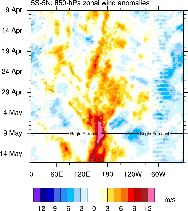
The most compelling difference between 2015 and 2014, however, is that the atmosphere finally appears to be responding strongly to warm ocean temperature anomalies. Easterly trade winds have slackened across the entire Pacific Basin, and a very strong westerly wind burst–on par with those which occurred in advance of the powerful 1997-1998 event–is currently ongoing near the Dateline. Further, observed SST anomalies in the far Eastern Pacific are now higher than those in the West Pacific, which means that the East-West anomaly difference is now greater than zero. El Niño is a tale of cascading, self-reinforcing feedbacks in the physical Earth system (which I discussed in a previous blog post on that topic)–and now, in 2015, it finally appears that these feedbacks are fully in play. El Niño is rapidly strengthening in 2015 at the same time it was falling apart in 2014. (CDAS/TAO via NOAA)
Another indicator of increased confidence in the forecast for 2015 is the eyebrow-raising amplitude of El Niño projections being generated by a wide range of ocean-atmosphere models. Several of these–including (but not limited to) the CFS and ECMWF models–are suggesting the strong potential for Niño 3.4 region SSTs peaking more than +3 degrees C during the coming autumn/winter. For reference, the highest values ever recorded were around +2.5C, and occurred during the strongest El Niño events on record in 1982-1983 and 1997-1998. In other words: a majority of the global atmosphere ocean models are currently suggesting the potential for an event rivaling the strongest event in the historical record. A powerful westerly wind burst–the strongest and most persistent since 1997–is currently ongoing in the West Pacific. (SUNY Albany)
It’s very important to reiterate, at this point, that just because the models are depicting a powerful El Niño later this year does not mean that such an event will actually come to pass. We need to look no further than last year for a stark illustration of that reality.
It’s also true that model forecasts through the month of May are still being generated in the midst of the so-called Spring Predictability Barrier–the period during which long-lead ENSO forecasts remain challenging due to the chaotic nature of the ocean-atmosphere system. I will note, though, that forecasts from May are notably better than those made in March or April, and that the projected peak strength of the current El Niño event has been monotonically rising with each month’s forecast so far in 2015 (while in 2014 the opposite was occurring). The North American Multi-Model Ensemble is showing the potential for an extraordinarily strong El Niño event in 2015. (CPC)
It’s still too early to discuss the potential implications of a strong El Niño event for California (I already did that last year, and I’ll do it again in a month or so if conditions warrant). Strong El Niño events do tend to increase the potential for very wet winters through most of California (especially in the south)–but they certainly do not eliminate the possibility of very dry winters, even on a statewide basis. If an event as strong as is currently being depicted by some of the dynamical models does occur in 2015, it’s hard to imagine California experiencing another year of below-average precipitation. But that’s a very big “if,” and one thing is certain: we have a long, dry summer to come. Originally Posted by Ernest_Hemingway

-
05-11-2015, 01:08 PM #206
 registered peruser
- Join Date
- May 2009
- Location
- inpdx
- Posts
- 20,240
[praying for pnw anomaly year dumpage]
-
06-18-2015, 07:53 AM #207
 GOES knows
- Join Date
- Apr 2006
- Location
- Wasatch
- Posts
- 7,273
No offense to your PNW, but we want to see a 1997 type event in the south
I need to go to Utah.
Utah?
Yeah, Utah. It's wedged in between Wyoming and Nevada. You've seen pictures of it, right?
So after 15 years we finally made it to Utah.....
Thanks BCSAR and POWMOW Ski Patrol for rescues
8, 17, 13, 18, 16, 18, 20, 19, 16, 24, 32, 35
2021/2022 (13/15)
-
07-09-2015, 10:29 AM #208
Registered User
- Join Date
- Jun 2006
- Location
- Seattle
- Posts
- 1,992
It is a long way out still, but sure not looking good...
Micro El Niño update
A new, powerful westerly wind burst is currently underway in the far western tropical Pacific, and is expected to strengthen/shift eastward in the coming days. (SUNY Albany)
With each passing week, it seems more and more likely that the world will experience a strong El Niño event in 2015. We’re almost there already–observed conditions are right at the official threshold for declaring a “strong event.” All major dynamical models suggest further strengthening, and several of the best models are still suggesting the potential for quite a bit of additional strengthening.
The latest runs of the CFS are continuing to call for the strongest El Niño event on record by the fall months–and this is starting to look more plausible as we have now mostly emerged from the so-called Spring Predictability Barrier. As of this writing, a new, powerful westerly wind burst was just beginning in the far West Pacific–a very strong sign that a third major Kelvin Wave may be on the way and that this El Niño event will continue to intensify for at least the next 3 months.
taken from: http://www.weatherwest.com/archives/3228
-
07-09-2015, 10:34 AM #209
Registered User
- Join Date
- Jun 2006
- Location
- Seattle
- Posts
- 1,992
The "official word"
EL NIÑO/SOUTHERN OSCILLATION (ENSO)
DIAGNOSTIC DISCUSSION
issued by
CLIMATE PREDICTION CENTER/NCEP/NWS
and the International Research Institute for Climate and Society
9 July 2015
ENSO Alert System Status: El Niño Advisory
Synopsis: There is a greater than 90% chance that El Niño will continue through Northern Hemisphere winter 2015-16, and around an 80% chance it will last into early spring 2016.
During June, sea surface temperatures (SST) anomalies exceeded +1.0oC across the central and eastern equatorial Pacific Ocean (Fig. 1). The largest SST anomaly increases occurred in the Niño-3 and Niño-3.4 regions, while the Niño-4 and Niño-1+2 indices remained more constant through the month (Fig. 2). Positive subsurface temperature anomalies weakened (Fig. 3) due to the eastward shift of an upwelling oceanic Kelvin wave, which reduced above-average temperatures at depth in the central and east-central equatorial Pacific (Fig. 4). In many respects, the atmospheric anomalies remained firmly coupled to the oceanic warming. Significant westerly winds were apparent in the western equatorial Pacific and anomalous upper-level easterly winds continued. The traditional and equatorial Southern Oscillation Index (SOI) were both negative, which are consistent with enhanced convection over the central and eastern equatorial Pacific and suppressed convection over Indonesia (Fig. 5). Collectively, these atmospheric and oceanic features reflect an ongoing and strengthening El Niño.
Nearly all models predict El Niño to continue into the Northern Hemisphere winter 2015-16, with many multi-model averages predicting a strong event at its peak strength (3-month values of the Niño-3.4 index of +1.5oC or greater; Fig. 6). At this time, the forecaster consensus is in favor of a significant El Niño in excess of +1.5oC in the Niño-3.4 region. Overall, there is a greater than 90% chance that El Niño will continue through Northern Hemisphere winter 2015-16, and around an 80% chance it will last into early spring 2016 (click CPC/IRI consensus forecast for the chance of each outcome for each 3-month period).
Across the contiguous United States, temperature and precipitation impacts associated with El Niño are expected to remain minimal during the Northern Hemisphere summer and increase into the late fall and winter (the 3-month seasonal outlook will be updated on Thursday July 16th). El Niño will likely contribute to a below normal Atlantic hurricane season, and to above-normal hurricane seasons in both the central and eastern Pacific hurricane basins (click Hurricane season outlook for more).
This discussion is a consolidated effort of the National Oceanic and Atmospheric Administration (NOAA), NOAA's National Weather Service, and their funded institutions. Oceanic and atmospheric conditions are updated weekly on the Climate Prediction Center web site (El Niño/La Niña Current Conditions and Expert Discussions). Forecasts are also updated monthly in the Forecast Forum of CPC's Climate Diagnostics Bulletin. Additional perspectives and analysis are also available in an ENSO blog. The next ENSO Diagnostics Discussion is scheduled for 13 August 2015. To receive an e-mail notification when the monthly ENSO Diagnostic Discussions are released, please send an e-mail message to: ncep.list.enso-update@noaa.gov.
Climate Prediction Center
National Centers for Environmental Prediction
NOAA/National Weather Service
College Park, MD 20740
-
07-09-2015, 02:41 PM #210
 R.I.P 2003-2017
- Join Date
- Feb 2005
- Location
- under the hogback shadow
- Posts
- 3,237
Does this mean it will snow at Keystone during Christmas week?
-
07-09-2015, 02:44 PM #211
Not on IR. For now.
- Join Date
- Jun 2006
- Location
- Couloirfornia
- Posts
- 8,871
https://twitter.com/BenNollWeather/s...772404224?s=04
https://pbs.twimg.com/tweet_video/CJZ_6tzUMAEx2yD.mp4User ActionsCFS & ECMWF show a "Jurassic" #ElNino for later this yr, beating all-time record by ~0.5C HT @philklotzbach #climate
https://twitter.com/EricBlake12/stat...185103360?s=04
http://www.slate.com/blogs/the_slate...h_all_dt_tw_ru
Lots of new stuff in the last few days. Originally Posted by Ernest_Hemingway
-
07-09-2015, 03:25 PM #212
Registered User
- Join Date
- Jun 2006
- Location
- Seattle
- Posts
- 1,992
Just the 26th and 27th. Originally Posted by Elkhound Odin

-
07-10-2015, 01:53 PM #213
 Registered User
- Join Date
- Aug 2010
- Location
- Park City
- Posts
- 1,870
Okay weather nerds, what does a strong el nino event typically mean for the Wasatch?
-
07-10-2015, 03:30 PM #214
Not on IR. For now.
- Join Date
- Jun 2006
- Location
- Couloirfornia
- Posts
- 8,871
Probably nothing. Originally Posted by Canada1
http://bestsnow.net/Neutral_areas.htm
Wasatch resorts are near the bottom of that chart. Strong ENSO events either way don't change the trend in the Wasatch much. Originally Posted by Ernest_Hemingway
-
08-18-2015, 09:38 PM #215
 AKA BeerMountaineer
- Join Date
- Apr 2008
- Location
- Boulder
- Posts
- 850
Japan? Canada? Alaska? Mrs. Spank and I are quitting our jobs in January to go skiing, but how do these places fare with el nino oh weather gods?
-
08-19-2015, 08:00 AM #216
Rollin with the Tide
- Join Date
- May 2006
- Location
- Eagle County
- Posts
- 12,618
Go to Mammoth....probably as good a bet right now as any.
ROLL TIDE ROLL
-
08-19-2015, 12:07 PM #217
Not on IR. For now.
- Join Date
- Jun 2006
- Location
- Couloirfornia
- Posts
- 8,871
Or Taos. Both great towns.
http://bestsnow.net/El_Nino.htm Originally Posted by Ernest_Hemingway
-
08-19-2015, 10:10 PM #218
 Falling Down
- Join Date
- Dec 2004
- Location
- SoCal
- Posts
- 6,753
Do both, the Mountain Collective recently added Taos.
-
09-09-2015, 03:16 PM #219
 Um, yeah, that guy


- Join Date
- Jan 2006
- Location
- Carbondale
- Posts
- 12,497
I was just going to post that.. and save some skrilla for a fly by night good old fashion storm chase. Originally Posted by 1000-oaks
www.dpsskis.com
www.point6.com
formerly an ambassador for a few others, but the ski industry is... interesting.
Fukt: a very small amount of snow.
-
09-15-2015, 01:26 PM #220
Registered User
- Join Date
- Jun 2006
- Location
- Seattle
- Posts
- 1,992
This post from a local meteorologist in PDX who usually does a pretty good job.
Strong El Nino This Winter: What About Cascade Snow?
https://fox12weather.wordpress.com/2...-cascade-snow/
-
10-10-2015, 10:33 PM #221
 ahhhh!
- Join Date
- Jan 2008
- Location
- livin the dream
- Posts
- 5,777
Central Coast CA surf is crazy warm and big this weekend. Good sign....
Best Skier on the Mountain
Self-Certified
1992 - 2012
Squaw Valley, USA
-
10-10-2015, 11:49 PM #222
 Type 7 stool
- Join Date
- May 2007
- Location
- Juxtaposition
- Posts
- 5,733
The last really big el nino in 97/98 was wet and warm in central Japan. Recall Nagano Winter Olympics. Having said that, the worst season I have seen in Japan in the last 8 was not an el nino year. Anything can happen when nuances and subtleties of weather play out in real life. Originally Posted by spankthepow
Goooood.... Originally Posted by spankthepow
[Last year I met some people in Golden BC who quit their jobs to ski a full season. God damn they were hurting internally after what transpired]Life is not lift served.
-
10-12-2015, 08:03 PM #223
Go Advanced
- Join Date
- Mar 2008
- Location
- West By God Wyoming
- Posts
- 674
EL NIÑO/SOUTHERN OSCILLATION (ENSO)
DIAGNOSTIC DISCUSSION
issued by
CLIMATE PREDICTION CENTER/NCEP/NWS
and the International Research Institute for Climate and Society
8 October 2015
ENSO Alert System Status: El Niño Advisory
Synopsis: There is an approximately 95% chance that El Niño will continue through Northern Hemisphere winter 2015-16, gradually weakening through spring 2016.
During September, sea surface temperature (SST) anomalies were well above average across the central and eastern Pacific Ocean (Fig. 1). The Niño indices generally increased, although the far western Niño-4 index was nearly unchanged (Fig. 2). Also, relative to last month, the strength of the positive subsurface temperature anomalies decreased slightly in the central and eastern Pacific (Fig. 3), but the largest departures remained above 6oC (Fig. 4). The atmosphere was well coupled with the ocean, with significant low-level westerly wind anomalies and upper-level easterly wind anomalies persisting from the western to the east-central tropical Pacific. Also, the traditional and equatorial Southern Oscillation Index (SOI) values became more negative (stronger), consistent with enhanced convection over the central and eastern equatorial Pacific and suppressed convection over Indonesia (Fig. 5). Collectively, these atmospheric and oceanic anomalies reflect a strong El Niño.
All models surveyed predict El Niño to continue into the Northern Hemisphere spring 2016, and all multi-model averages predict a peak in late fall/early winter (Fig. 6). The forecaster consensus unanimously favors a strong El Niño, with peak 3-month SST departures in the Niño 3.4 region near or exceeding +2.0oC. Overall, there is an approximately 95% chance that El Niño will continue through Northern Hemisphere winter 2015-16, gradually weakening through spring 2016 (click CPC/IRI consensus forecast for the chance of each outcome for each 3-month period).
Across the United States, temperature and precipitation impacts from El Niño are likely to be seen during the upcoming months (the 3-month seasonal outlook will be updated on Thursday October 15th). Outlooks generally favor below-average temperatures and above-median precipitation across the southern tier of the United States, and above-average temperatures and below-median precipitation over the northern tier of the United States.
This discussion is a consolidated effort of the National Oceanic and Atmospheric Administration (NOAA), NOAA's National Weather Service, and their funded institutions. Oceanic and atmospheric conditions are updated weekly on the Climate Prediction Center web site (El Niño/La Niña Current Conditions and Expert Discussions). Forecasts are also updated monthly in the Forecast Forum of CPC's Climate Diagnostics Bulletin. Additional perspectives and analysis are also available in an ENSO blog. The next ENSO Diagnostics Discussion is scheduled for 12 November 2015. To receive an e-mail notification when the monthly ENSO Diagnostic Discussions are released, please send an e-mail message to: ncep.list.enso-update@noaa.gov.
-
10-16-2015, 05:17 PM #224
Registered User
- Join Date
- Nov 2008
- Posts
- 1,441
So whats this mean for Yurp? Been looking around but im unable to find any info
-
10-17-2015, 09:32 AM #225
Minion
- Join Date
- Oct 2015
- Posts
- 1
Weather Gurus
So, I hate to ask questions without doing some research, but I am not entirely sure if I am understanding some of the data I have looked at.
My understanding the last time we had an el nino event of this strength the Lone Peak / Big Sky area saw above average snow falls, not significantly, but bestsnow.net still lists them as above average. Mean while Bridger bowl reports below average. Is it likely we can expect that same kind of weather with this event? It seems strange looking at the maps that south western Montana would see anything "Above average" based on the visual ive been presented with here.
Thanks!

 Reply With Quote
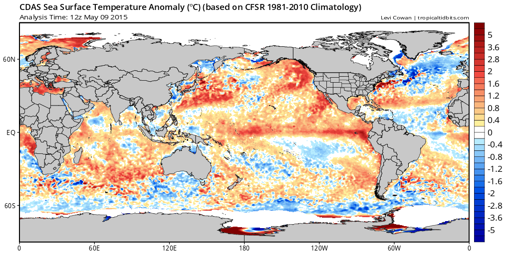


 Ben Noll@BenNollWeather
 Eric Blake@EricBlake12
Bookmarks